New York State Route 13
From Wikipedia, the free encyclopedia
 |
|||||||||||||
| NY Route 13 |
|||||||||||||
 |
|||||||||||||
| Length: | 152.30 mi[1] (245.10 km) | ||||||||||||
|---|---|---|---|---|---|---|---|---|---|---|---|---|---|
| Formed: | 1924[2] | ||||||||||||
| South end: | |||||||||||||
| Major junctions: |
|||||||||||||
| North end: | |||||||||||||
| Counties: | Chemung, Schuyler, Tompkins, Cortland, Madison, Oneida, Oswego | ||||||||||||
|
|||||||||||||
New York State Route 13 is a 152.30-mile (245.10 km) long state highway that runs mainly north-south between NY 14[citation needed] in Horseheads and NY 3 west of Pulaski in Central New York, United States. In between, NY 13 intersects with Interstate 81 in Cortland and the New York State Thruway (Interstate 90) in Canastota.
The most heavily traveled section of the route is the 50 mile (90 km) northeast/southwest section between Horseheads and Cortland, servicing Ithaca. At one point it was proposed to convert this part of NY 13 into an expressway, however this plan quickly fell out of favor with local residents. A small stretch of NY 13 follows an expressway alignment in the Ithaca area.
NY 13 is co-signed with several routes along its routing, most notably NY 34 and NY 96 between Newfield and Ithaca; NY 80 between DeRuyter and Cazenovia; and NY 5 between Chittenango and Canastota.
When NY 13 was originally assigned in the 1920s, it extended only from Elmira to Cazenovia. It was significantly extended in 1930, stretching from Lindley in the south to Richland in the north. The southern terminus was moved back to Elmira in the 1940s and has been located at various points in the city since then.
Contents |
[edit] Route description
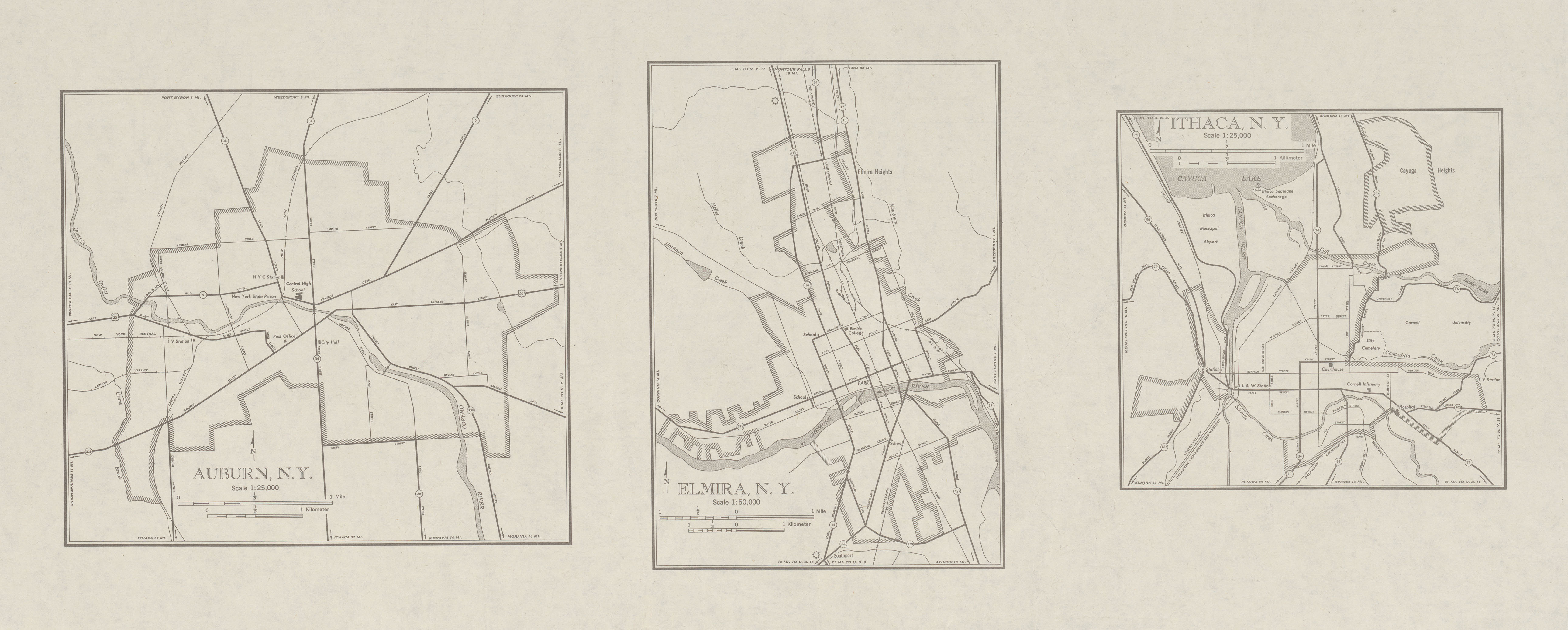
[edit] Elmira to Ithaca
Up until 2006, NY 13 began at exit 54 on the Southern Tier Expressway (NY 17) southeast of the village of Horseheads. However, as part of the Horseheads Bypass project, NY 13 was extended west into the village to NY 14 along the frontage roads for the expressway.[citation needed] North of NY 17, NY 13 heads north through the town of Horseheads, paralleling the eastern edge of the village to an intersection with NY 223 near the northern town line. As NY 13 passes out of Horseheads and into Veteran, the amount of development along the roadway becomes sparse, consisting of only small roadside hamlets.
Just before exiting Chemung County, NY 13 turns northeast toward the city of Ithaca several miles to the northeast. The route soon enters the narrow southeastern extents of Schuyler County, where it intersects NY 224 before crossing county lines again, this time into Tompkins County. NY 13 remains largely rural in nature, passing only one significant settlement—the Newfield hamlet of the same name—on its way to the town of Ithaca. Shortly after entering the town, the route interchanges with the concurrent routes of NY 34 and NY 96 adjacent to Robert H. Treman State Park. Both routes join NY 13 north alongside the eastern edge of the park to NY 327, a road largely delimiting the northern extent of the park. An intersection with NY 13A in the vicinity of Buttermilk Falls State Park, an alternate route of NY 13 through western Ithaca, soon follows as Routes 13, 34, and 96 enter the city limits.
At West Clinton Street (NY 96B), the route splits into a one-way pair, with Meadow Street carrying northbound traffic and Fulton Street handling southbound traffic. Due to the configuration of the city street grid, NY 79 overlaps the three-route concurrency on Fulton Street for one block eastbound as it switches from West State Street to West Green Street; no such overlap exists westbound/northbound as NY 79 westbound remains on West Seneca Street, where NY 96 leaves NY 13/34 and joins NY 79. The one-way pair comes to an end near Hancock Street, at which point both directions of the route merge into Meadow Street and continue northeastward through the city as an at-grade roadway. At Dey Street, however, the road becomes a limited-access highway as it heads through the northern extents of the city and partially alongside Cayuga Lake.
Near the northern city line, the roadway interchanges with East Shore Drive, at which point NY 34 leaves the expressway to follow East Shore Drive along the lakeshore. NY 13 and NY 34 follow parallel routings into Lansing, where NY 13 curves eastward to interchange with both Cayuga Heights Road and Triphammer Road. Southwest of the Tompkins County Airport, NY 13 downgrades into a divided highway and meets Warren Road at-grade before reverting into a two-lane roadway as it passes south of the airport and exits the Ithaca area.
[edit] Ithaca to Lenox
NY 13 progresses southeast through western Dryden to meet Dryden Road (NY 366), a street originating in eastern Ithaca. NY 366 joins NY 13 northeast along Fall Creek for little more than 1 mile (1.6 km) before splitting; however, the Dryden Road name remains with NY 13 into the village of Dryden. At the village center, NY 13 meets both NY 38 and NY 392. NY 13 turns north, overlapping NY 38 for three blocks and passing Tompkins Cortland Community College as it exits the village limits on Cortland Road.
At the Tompkins-Cortland County line, NY 13 loses the Cortland Road moniker and becomes unnamed as it heads toward Cortland. Southwest of the city limits, NY 13 breaks to the northeast, with its north-northeastward alignment continuing onward as NY 281. In Cortland, NY 13 becomes Tompkins Street and meets NY 215 (Owego Street) three blocks from an intersection with the overlapping routes of U.S. Route 11 and NY 41 at Church Street. All three routes turn north onto Church, creating a three-route overlap that lasts for three blocks through downtown Cortland. At Clinton Road, US 11 and NY 41 turn west while NY 13 curves east for several blocks to an interchange with Interstate 81 at the northeastern edge of the city's downtown district. Here, the Tioughnioga River splits, with NY 13 following the eastern branch northeast out of the Cortland city limits.
NY 13 continues northeast along the banks of the Tioughnioga through Truxton, where it intersects the southern terminus of NY 91, to the hamlet of Cuyler in the town of the same name. Here, the river downgrades to a creek as the route turns eastward toward Madison County. Upon crossing the county line, NY 13 enters the village of DeRuyter as Cortland Street. In the village center, NY 13 turns left onto Utica Street and follows the roadway out of the village.
Within the town of DeRuyter, NY 13 follows a largely northeast-southwest alignment as it passes through the hamlet of Puckerville (centered around the junction between NY 13 and East Lake Road, a local roadway following the eastern edge of the DeRuyter Reservoir) to Sheds, a small hamlet marked by the intersection of NY 13 and NY 80. NY 13 turns north, overlapping NY 80 north for 3 miles (4.8 km) to the Cazenovia community of New Woodstock, where NY 13 leaves NY 80 at the western fringe of the hamlet.
NY 13 heads north to the village of Cazenovia, located at the southeastern tip of Cazenovia Lake. Within the village limits, NY 13 overlaps U.S. Route 20 on Forman and Albany Streets before continuing north out of the village on Farnham and Sweetland Streets. In the town, the street becomes known as Gorge Road and enters a roughly 100 feet (30 m) ravine surrounding the Chittenango Creek. As NY 13 progresses northward, the gorge deepens, reaching approximately 300 feet (91 m) within Chittenango Falls State Park. North of the park, the gorge widens laterally and continues to drop in elevation, with the difference between the surrounding terrain and NY 13 reaching almost 500 feet (150 m) as it intersects NY 5 in southeastern Chittenango. The two routes overlap, following Genesee Street north for several blocks before turning east and paralleling the former Erie Canal out of the village.
The two routes remain conjoined until Canastota, where NY 13 breaks from NY 5 and resumes its northward progression. North of the village center, NY 13 interchanges with the New York State Thruway (Interstate 90) at exit 34 before exiting Canastota and entering Lenox. At the southeastern corner of Oneida Lake, NY 13 intersects NY 31. Just north of NY 31, NY 13 crosses over the Oneida River and enters Oneida County.
[edit] Oneida and Oswego Counties
Between the county line and NY 49, NY 13 follows the eastern edge of Oneida Lake as it proceeds northward through the towns of Verona and Vienna. In Verona, NY 13 passes through the center of Verona Beach State Park and serves the lakeside community of Verona Beach, located adjacent to where the Erie Canal exits Oneida Lake. NY 13 crosses over the canal shortly afterward, passing into the Vienna community of Sylvan Beach in the process. Development along NY 13 continues as far north as Edgewater Beach, where NY 13 breaks from the lakeshore and continues north to meet NY 49. NY 13 turns east, overlapping NY 49 into the hamlet of Vienna.
In the center of Vienna, NY 13 leaves NY 49 and continues northward through the hamlet of McConnellsville (where NY 13 is joined by the west branch of Fish Creek) to the village of Camden, where NY 69 overlaps NY 13 for two blocks through the heart of the village. Past Camden, NY 13 continues northwest along Fish Creek into the Oswego County town of Williamstown, where NY 13 leaves the waterway and intersects NY 183 and NY 104.
NY 13 continues onward through rural central Oswego County to the village of Pulaski, where the route interchanges with southbound Interstate 81 just outside the village and intersects U.S. Route 11 near the center of Pulaski. The route continues west for another 3 miles (4.8 km) before terminating at NY 3 in the town of Richmond.
[edit] History
[edit] Early routing
When state highways in New York were first publicly signed in 1924, NY 13 was assigned only to the portion of its modern routing between Elmira and Cazenovia.[2] Within the Elmira area, NY 13 initially followed a different routing, beginning at the intersection of Lake Street and Water Street (then NY 17) on the north bank of the Chemung River in downtown Elmira. The route then overlapped NY 14 along Lake Street to Horseheads,[3] where NY 13 split from NY 14 and headed northeast on Old Ithaca Road to what is now the intersection between NY 13 and NY 223. Here, NY 13 turned north, following its current alignment toward Ithaca.[4]
In the 1930 renumbering, NY 13 was extended over previously unnumbered roadways on both ends of its alignment. To the south, NY 13 was extended along Water Street (modern NY 352) to West Elmira, then on what is now NY 225 west to Caton. Past Caton, NY 13 continued west to NY 2 (now U.S. Route 15) in Lindley by way of Tannery Creek Road, River Road, and Morgan Creek Road (now collectively Steuben County Road 120).[5] In the north, NY 13 was extended northward along its modern routing to NY 3C (modern NY 3) west of Pulaski.[6][7]
[edit] Realignments and truncation
The southern terminus of NY 13 was moved back to Elmira during the 1940s; however, NY 13 now overlapped a realigned NY 17 between its terminus at Water Street and the center of Horseheads, where NY 17 joined NY 14 to meet its old alignment south of Horseheads.[8][9] NY 17 was moved onto its current alignment east of the city in the late 1950s;[10][11] NY 13 was later realigned south of NY 223 to follow a new road leading to a newly-constructed interchange with NY 17 in the 1960s.[12]
In the mid-1980s, the Sullivanville Dam project forced a portion of the route to be rerouted northeast of Horseheads. Due to the elevated water level caused by the dam, the route had to be moved to higher ground west of the hamlet of Sullivanville in the Town of Veteran. A section of the old highway remains under the impounded water. Another section north of the dam exists as an extension of Sullivanville Road.[citation needed]
In 2007, with the completion of the I-86 project, Route 13 was extended westward along the parallel collector/distributor roads to NY 14 in Horseheads.[citation needed] Prior to the project's completion, at least one "NY 13 South" sign assembly was exposed along the westbound frontage road leading from exit 54 (NY 13).[citation needed] Several similarly shaped signs on similar sign assemblies were covered along the route.[citation needed]
[edit] Routing through Ithaca
From its current alignment on Meadow Street, NY 13 was once co-signed with NY 79 through downtown Ithaca, then followed Mitchell Street and Dryden Road (now NY 366) through the Cornell Plantations, before continuing on to Dryden. In the early 1970s, a new expressway was built along the eastern shore of Cayuga Lake, bypassing downtown Ithaca on the west and north. After this, Meadow Street carried NY 13 traffic in both directions along the western edge of Ithaca until the late 1990s, when southbound traffic was diverted from Meadow Street to Fulton Street for a ten block section.[13]
This new expressway was pictured on the Voyager Golden Record as an example of a "modern highway."[14]
[edit] NY 13A

NY 13A (2.08 miles (3.35 km)[1]) is a north-south spur assigned by 1948[15] that bypasses downtown Ithaca by way of the Town of Ithaca to the southwest. The route begins at NY 13 (here concurrent to NY 34 and NY 96) south of the city near the former Tutelo village of Coreogonel, at the confluence of Buttermilk Creek and the Cayuga Lake inlet, just south of the entrance to Buttermilk Falls State Park. NY 13A heads north, following the west bank of the Cayuga Flood Control Channel into the city, where it ends at NY 79 and Elm Street in Ithaca's West End, an area once dominated by squatters' villages.[16] Within the city, NY 13A is known as Floral Avenue. In the town of Ithaca, it is known as Five Mile Drive, so named because it is five miles from Cayuga Lake.
[edit] Major intersections
| County | Location | Mile[1] | Roads intersected | Notes |
|---|---|---|---|---|
| Chemung | Village of Horseheads | 0.00 | Exit 54 (I-86/NY 17) | |
| Veteran | 2.78 | Western terminus of NY 223 | ||
| Schuyler | Cayuta | 11.64 | ||
| Tompkins | Town of Ithaca | 23.65 | Southern terminus of overlap | |
| 24.15 | Southern terminus of NY 327 | |||
| 25.22 | Southern terminus of NY 13A | |||
| City of Ithaca | 27.31 | Northern terminus of NY 96B | ||
| 27.43 | Southern terminus of overlap (southbound) | |||
| 27.55 | Northern terminus of overlap (southbound) | |||
| 27.63 | Northern terminus of NY 13/96 overlap; southern terminus of NY 89 | |||
| Cayuga Heights | 29.24 | Northern terminus of overlap; diamond interchange | ||
| Cayuga Heights Road | Partial cloverleaf interchange; former routing of NY 34A | |||
| 31.21 | North Triphammer Road | Diamond interchange | ||
| Town of Dryden | 35.32 | Western terminus of overlap | ||
| 36.55 | Eastern terminus of overlap | |||
| Village of Dryden | 41.28 | Southern terminus of overlap; western terminus of NY 392 | ||
| 41.81 | Northern terminus of overlap | |||
| Cortland | Cortlandville | 48.76 | Southern terminus of NY 281 | |
| Cortland | 50.93 | Northern terminus of NY 215 | ||
| 51.34 | Southern terminus of overlap | |||
| 51.65 | Northern termini of US 11/NY 13 and NY 13/41 overlaps; eastern terminus of NY 222 | |||
| 52.41 | Exit 11 (I-81) | |||
| Truxton | 62.98 | Southern terminus of NY 91 | ||
| Madison | Town of DeRuyter | 76.24 | Southern terminus of overlap | |
| Town of Cazenovia | 79.68 | Northern terminus of overlap | ||
| Village of Cazenovia | 85.67 | Southern terminus of overlap | ||
| 86.26 | Northern terminus of overlap | |||
| Chittenango | 95.40 | Western terminus of overlap | ||
| Canastota | 101.98 | Eastern terminus of overlap | ||
| 103.51 | Exit 34 (I-90/Thruway) | |||
| Lenox | 108.59 | |||
| Oneida | Vienna | 114.19 | Western terminus of overlap | |
| 115.64 | Eastern terminus of overlap | |||
| Village of Camden | 123.39 | Southern terminus of overlap | ||
| 123.49 | Northern terminus of overlap | |||
| Oswego | Williamstown | 133.25 | Northern terminus of NY 183 | |
| 136.39 | Eastern terminus of NY 104 | |||
| Pulaski | 148.37 | Exit 36 (I-81) | ||
| 149.14 | ||||
| Richland | 152.30 |
[edit] References
- ^ a b c Traffic Data Report - US 9 to NY 15 (PDF). NYSDOT (2007-07-16). Retrieved on 2007-12-03.
- ^ a b "New York's Main Highways Designated by Numbers", New York Times, 1924-12-21, p. XX9.
- ^ Automobile Blue Book, Inc. Automobile Blue Book (Elmira, NY inset) [map]. (1929) Retrieved on 2007-12-03.
- ^ Automobile Blue Book (Section 6). Automobile Blue Book, Inc (1929). Retrieved on 2007-12-03.
- ^ Pennsylvania Department of Highways. Tourist Map of Pennsylvania [map]. (1930) Retrieved on 2007-12-03.
- ^ Leon A. Dickinson. "New Signs for State Highways", New York Times, 1930-01-12, p. 136.
- ^ Automobile Legal Association (ALA) Automobile Green Book, 1930/31 and 1931/32 editions, (Scarborough Motor Guide Co., Boston, 1930 and 1931). The 1930/31 edition shows New York state routes prior to the 1930 renumbering
- ^ Pennsylvania Department of Highways. Official Road Map of Pennsylvania [map]. (1940) Retrieved on 2007-12-03.
- ^ Pennsylvania Department of Highways. Official Road Map of Pennsylvania [map]. (1950) Retrieved on 2007-12-03.
- ^ United States Geological Survey. Elmira Quadrangle - New York-Pennsylvania [map], 1 : 62,500, 15 Minute Series (Topographic). (1953) Retrieved on 2007-12-03.
- ^ Pennsylvania Department of Highways. Official Map of Pennsylvania [map]. (1960) Retrieved on 2007-12-03.
- ^ Pennsylvania Department of Highways. Official Map of Pennsylvania [map]. (1970) Retrieved on 2007-12-03.
- ^ New York Routes - New York State Route 13. Retrieved on 2007-12-03.
- ^ Modern Highway. Retrieved on 2008-05-29.
- ^ Map of Ithaca, NY. United States Geological Survey (1948). Retrieved on 2007-11-02.
- ^ 14850 Magazine Online: Go West, Young Eatery

