Image:KatrinaNewOrleansFlooded edit2.jpg
From Wikipedia, the free encyclopedia
Size of this preview: 456 × 599 pixels
Full resolution (1,153 × 1,514 pixels, file size: 1.23 MB, MIME type: image/jpeg)
| | This is a file from the Wikimedia Commons. The description on its description page there is shown below.
|
| This is a featured picture, which means that members of the community have identified it as one of the finest images on the English Wikipedia, adding significantly to its accompanying article. If you have a different image of similar quality, be sure to upload it using the proper free license tag, add it to a relevant article, and nominate it. |
| This image was selected as picture of the day on the English Wikipedia for August 29, 2008. |
| This is a featured picture on English Wikipedia and is considered one of the finest images. This is a featured picture on Spanish Wikipedia and is considered one of the finest images.
|
[edit] Summary
| Description |
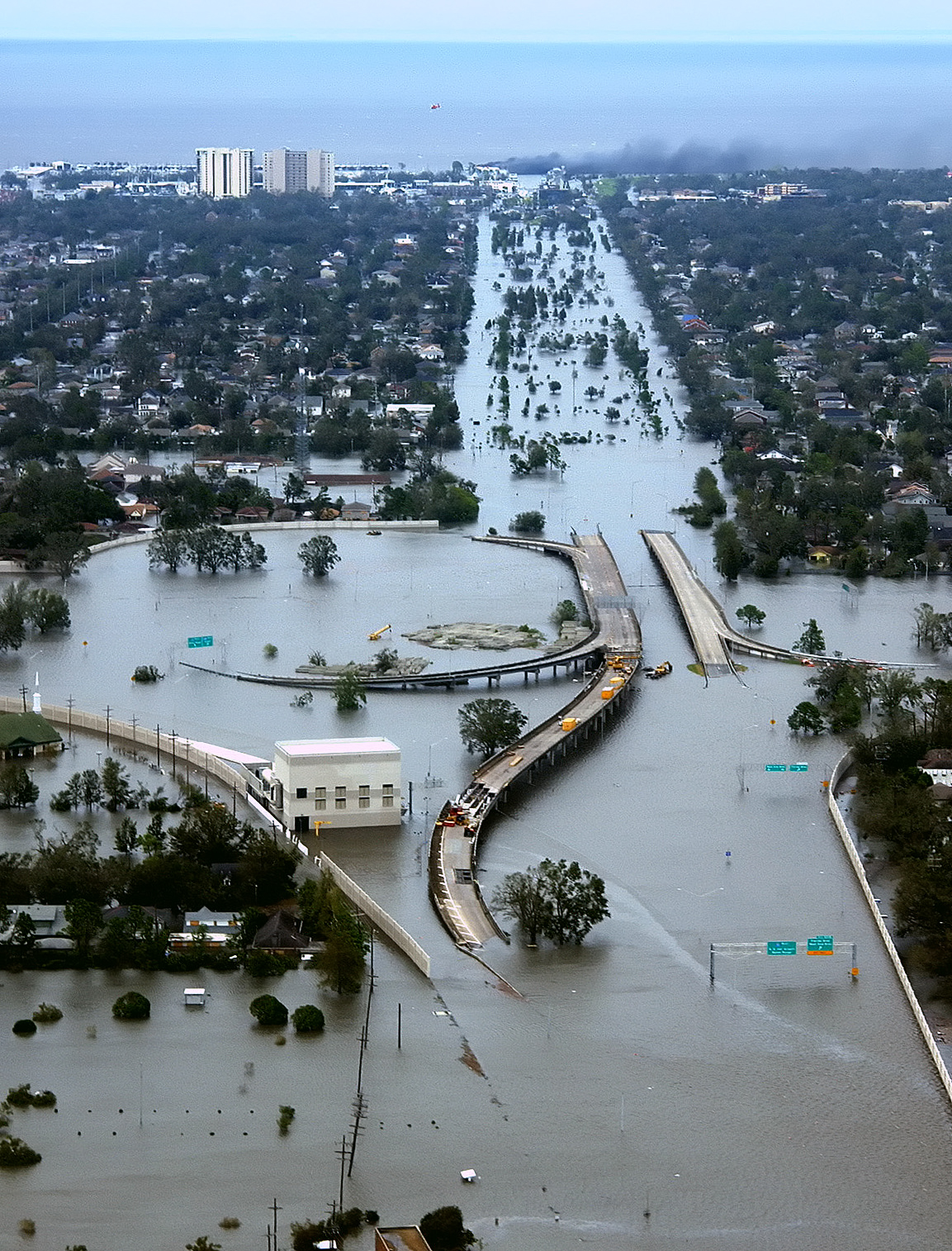
New Orleans, Louisiana in the aftermath of Hurricane Katrina (2005:08:29 17:24:22), showing Interstate 10 at West End Boulevard, looking towards Lake Pontchartrain. The 17th Street Canal is just beyond the left edge of the image. The breach in the levee of that canal was responsible for much of the flooding of the city in the hours after the hurricane. In the foreground, the intersection is the juncture of I-10, running from the bottom of the photo and curving out of the photo to the left, with the western end of I-610, which extends off the photo from the center right, and the West End entrance/exit from I-10. The block shaped building at center left front is a pumping station, one of those used to pump water from heavy rains off city streets in more normal times. The far eastern end of Veterans Memorial Boulevard is seen just back from the interchange extending to the left. The view looks north toward Lake Pontchartrain. The stretch of ground with no buildings from the Interchange to the lake is Pontchartrain Blvd. (on the left) and West End Blvd. (on the right), with a linear park (formerly the route of the New Basin Canal) between them. Smoke can be seen rising near the lake, probably from the burning of the Southern Yacht Club building. This photo provided by the U.S. Coast Guard shows flooded roadways as the Coast Guard conducted initial Hurricane Katrina damage assessment overflights of New Orleans, Monday Aug. 29, 2005. Edit, selective noise reduction by Mfield Deutsch: Das überflutete New Orleans
Español: La ciudad de Nueva Orleans, después del paso del Katrina. El foto aqui muestra la carretera 10 despues del huracan.
Suomi: 80% New Orleansista jäi veden alle, kun hurrikaani Katrina iski Yhdysvaltain rannikolle elokuussa 2005
|
|||
|---|---|---|---|---|
| Source |
Published here and here |
|||
| Date |
2005-08-29 |
|||
| Author |
AP Photo/U.S. Coast Guard, Petty Officer 2nd Class Kyle Niemi |
|||
| Permission (Reusing this image) |
|
|||
| Other versions |

|

 |
This is a retouched picture, which means that it has been digitally altered from its original version. Modifications: Selective noise reduction by User:Mfield. |
| This is a featured picture at the english wikipedia project. The nomination can be found here. If you think it should be featured on the Commons as well or have an image of similar quality that can be published under a suitable copyright license, be sure to upload it, tag it, and nominate it. |
File history
Click on a date/time to view the file as it appeared at that time.
| Date/Time | Dimensions | User | Comment | |
|---|---|---|---|---|
| current | 03:26, 18 April 2008 | 1,153×1,514 (1.23 MB) | Mfield | (== Summary == {{Information |Description=New Orleans, Louisiana in the aftermath of Hurricane Katrina (2005:08:29 17:24:22), showing Interstate 10 at West End Boulevard, looking towards Lake Pontchartrain. The 17th Street Canal is just beyond the left e) |
File links
- Wikipedia:Featured pictures
- 2005 Atlantic hurricane season
- User:E. Brown
- Portal:United States
- Habitat destruction
- User talk:Spikebrennan
- User:Spikebrennan
- User:RattleMan
- Hurricane Katrina
- Effects of Hurricane Katrina in New Orleans
- User:UniReb
- Pontchartrain Expressway
- User:WestJet
- User:Abyab
- User:Canuck85
- User:Fishhead
- Wikipedia:Userboxes/Seasonal
- User:Lionheart Omega
- User talk:Mfield
- User:UBX/remember Katrina
- User:PolitiCalypso
- User:Robomaeyhem
- User talk:Hurricanehink/Archive 2
- User:VerruckteDan
- User:Omni ND/Userboxes
- User:Lavishluau
- User:Eastlaw/UBX
- User:Krzysiu Jarzyna
- Portal:United States/Selected article
- User:Samwisep86
- User:UBX/Userboxes/Seasonal
- User:Bud0011
- User:Starry.dreams/My Userboxes
- User:Staroftheshow86
- User:Tom H.
- Portal:Tropical cyclones/Selected picture/New Orleans flooded
- User:Anadirgrowlslayer
- User:Jackbirdsong
- User:Svartulfr1
- User:Mvp7
- Portal:Tropical cyclones/Featured article/Effects of Hurricane Katrina on New Orleans
- User:J Klein
- User:Leon2323/Userboxes/August
- User:Vikingboy0129
- User:Yugioh1126
- User:MKLPTR
- User:SBD1138
- User:Whatever626
- User:Ilovesims2
- User:RingtailedFox/About
- User:Cadet hastings
- User:Tiggs97
- User:MattC13
- User:Cosmic Latte
- User:Dr. Hannibal Lecter
- Portal:United States/Selected article/3
- User:Saber girl08/userboxen
- User:Kinglou135
- User:Jer10 95/Userboxes
- User:Pilover819
- User:Foxtrotman
- User:Anonyminous
- Floods in the United States: 2001-present
- User:Arenafoot
- User:Realist2
- User:Jabba78
- User:Inglewoodplz
- User:Dgatto
- Portal:Louisiana/Selected picture
- Portal:Louisiana/Selected picture/5
- User:Wildhartlivie/Viewpoints & Politics
- User:Khoffm44
- User:Ayyah tubby
- User:Jaxfl/Userboxes
- User:Schumi555
- User:Hportfacts5
- User:Indigo Rush
- User:Godgiven Love
- Wikipedia:Featured pictures thumbs 12
- User:Blood Lines of Darkness
- User:Pilover819/OtherT
- User:Foxtrotman/Userboxes
- User:Pilover819/LOUBX
- Wikipedia:Featured picture candidates/April-2008
- Wikipedia:Featured pictures/Natural phenomena/Weather
- Wikipedia:Featured picture candidates/Hurricane Katrina flooding (edit 1)
- User:With What All
- Template:POTD/2008-08-29
Metadata
This file contains additional information, probably added from the digital camera or scanner used to create or digitize it. If the file has been modified from its original state, some details may not fully reflect the modified file.
| Orientation | Normal |
|---|---|
| Horizontal resolution | 72 dpi |
| Vertical resolution | 72 dpi |
| Software used | Adobe Photoshop CS3 Macintosh |
| File change date and time | 20:24, 17 April 2008 |
| Color space | sRGB |

