Image:Twotales.gif
From Wikipedia, the free encyclopedia
No higher resolution available.
Twotales.gif (301 × 200 pixels, file size: 16 KB, MIME type: image/gif)
| | This is a file from the Wikimedia Commons. The description on its description page there is shown below.
|
| Description |
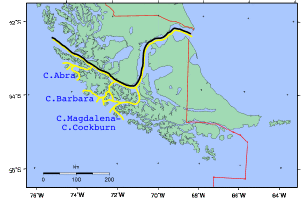
The two versions of the course of the Strait of Magellan during the Beagle conflict: the black course is the Chilean sight and the yellow course (delta) is the Argentine sight. |
|||
|---|---|---|---|---|
| Source |
self-made |
|||
| Date |
2008 |
|||
| Author | ||||
| Permission (Reusing this image) |
|

File history
Click on a date/time to view the file as it appeared at that time.
| Date/Time | Dimensions | User | Comment | |
|---|---|---|---|---|
| current | 17:24, 10 May 2008 | 301×200 (16 KB) | Createaccount | ({{Information |Description= The two versions of the course of the Strait of Magellan during the Beagle conflict: the black course is the Chilean sight and the yellow course (delta) is the Argentine sight. |Source=self-made |Date=2008 |Author= [[User:Crea) |
File links
The following pages on the English Wikipedia link to this file (pages on other projects are not listed):

