Image:Top of Atmosphere.jpg
From Wikipedia, the free encyclopedia
Size of this preview: 800 × 531 pixels
Full resolution (3,027 × 2,010 pixels, file size: 543 KB, MIME type: image/jpeg)
| | This is a file from the Wikimedia Commons. The description on its description page there is shown below.
|
| This is a featured picture, which means that members of the community have identified it as one of the finest images on the English Wikipedia, adding significantly to its accompanying article. If you have a different image of similar quality, be sure to upload it using the proper free license tag, add it to a relevant article, and nominate it. |
| This image was selected as picture of the day on the English Wikipedia for July 17, 2007. |
| This is a featured picture on English Wikipedia and is considered one of the finest images. This is a featured picture on Turkish Wikipedia and is considered one of the finest images.
|
| Description |
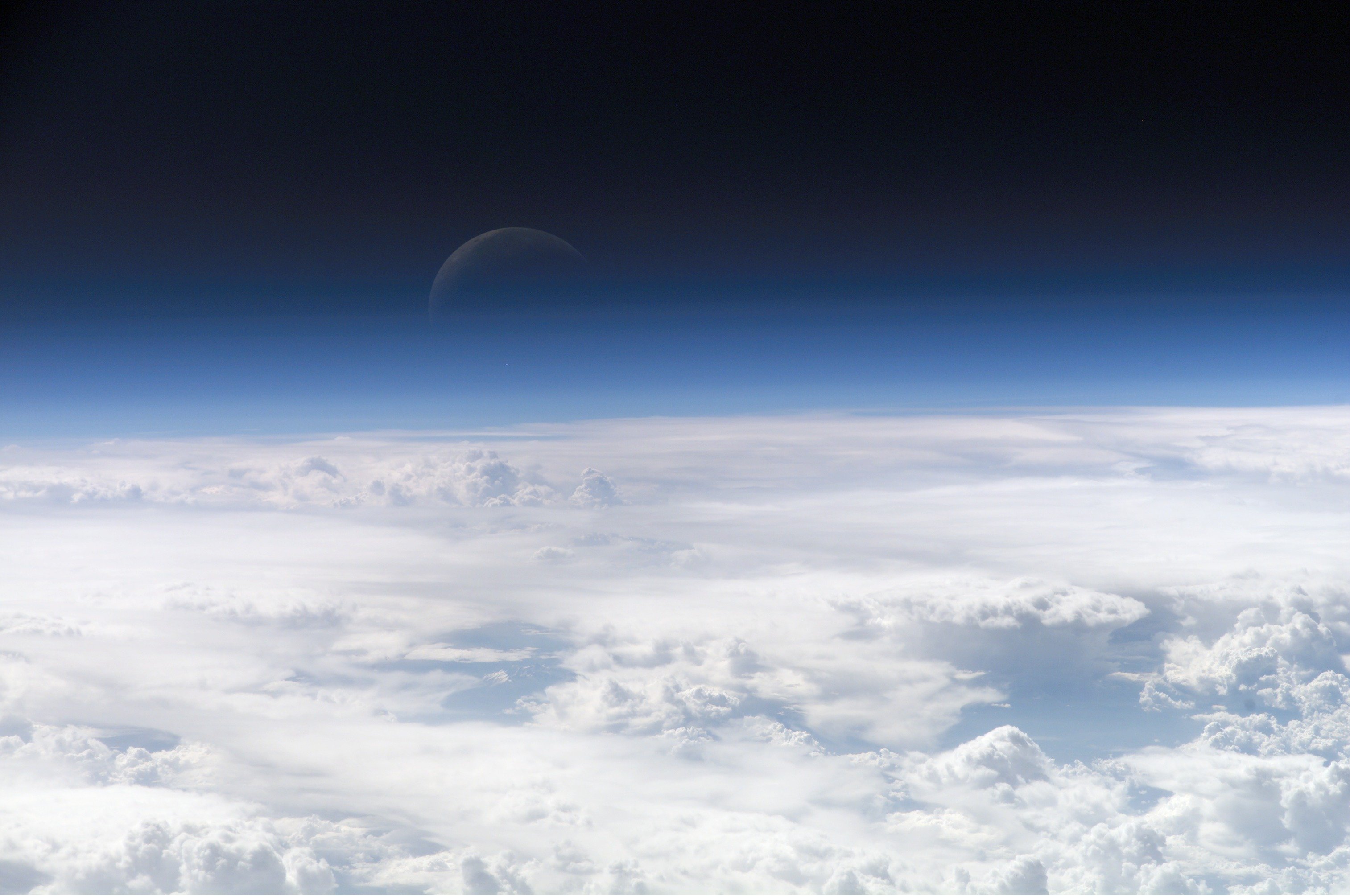
Image of the top layers of the earth's atmosphere leading to space |
|---|---|
| Source | |
| Date |
July 20 2006 |
| Author |
NASA's Earth Observatory |
| Permission (Reusing this image) |
"Image courtesy of Earth Sciences and Image Analysis Laboratory, NASA Johnson Space Center." |
| This image or video was catalogued by one of the centers of the United States National Aeronautics and Space Administration (NASA) under Photo ID: ISS013-E-54329. This tag does not indicate the copyright status of the attached work. A normal copyright tag is still required. See Commons:Licensing for more information. |

|
|
This file is in the public domain because it was created by NASA. NASA copyright policy states that "NASA material is not protected by copyright unless noted". (NASA copyright policy page or JPL Image Use Policy).
Deutsch | English | Español | Français | Nederlands | Português | Русский | 中文(简体) | 中文(繁體) | +/- |
|
 |
Warnings:
|
link title==Image information== Identification
Mission: ISS013 Roll: E Frame: 54329 Mission ID on the Film or image: ISS013
Country or Geographic Name:
Features: EARTH LIMB, MOON, CLOUD TOPS
Center Point Latitude: Center Point Longitude: (Negative numbers indicate south for latitude and west for longitude)
Stereo: (Yes indicates there is an adjacent picture of the same area)
ONC Map ID: JNC Map ID:
'MORALES'
Camera Tilt: Low Oblique
Camera Focal Length: 400mm
Camera: E4: Kodak DCS760C Electronic Still Camera
Film: 3060E : 3060 x 2036 pixel CCD, RGBG array.
Quality
Film Exposure:
Percentage of Cloud Cover: 100 (76-100)
Nadir
Date: 20060720 (YYYYMMDD)GMT Time: 082858 (HHMMSS)
Nadir Point Latitude: 21.5, Longitude: 113.3 (Negative numbers indicate south for latitude and west for longitude)
Nadir to Photo Center Direction:
Sun Azimuth: 281 (Clockwise angle in degrees from north to the sun measured at the nadir point)
Spacecraft Altitude: 181 nautical miles (335 km)
Sun Elevation Angle: 35 (Angle in degrees between the horizon and the sun, measured at the nadir point)
Orbit Number: 3839
[edit] Source
File history
Click on a date/time to view the file as it appeared at that time.
| Date/Time | Dimensions | User | Comment | |
|---|---|---|---|---|
| current | 08:09, 27 February 2007 | 3,027×2,010 (543 KB) | SirGrant | ({{Information |Description= Image of the top layers of the earth's atmosphere leading to space |Source= [http://eobadmin.gsfc.nasa.gov/Newsroom/NewImages/images.php3?img_id=17542] direct link:[http://eobadmin.gsfc.nasa.gov/Newsroom/NewImages/Images/ISS01) |
File links
- Planet
- Atmospheric sciences
- Earth's atmosphere
- Atmosphere
- Kármán line
- Atmosphere of Mars
- User:RCSIRCSIRCSI
- User:DarkAngel007
- Atmosphere of Venus
- Wikipedia:Featured pictures/Views of Earth from space and satellites
- Wikipedia:Featured pictures thumbs 07
- User talk:PBeaver
- Atmosphere of the Moon
- Wikipedia:Featured picture candidates/March-2007
- Wikipedia:Featured picture candidates/Earth's atmosphere
- Wikipedia:Wikipedia Signpost/2007-03-26/Features and admins
- User:.V./test
- User talk:KFP/Archive 4
- Wikipedia:Wikipedia Signpost/2007-03-26/SPV
- Wikipedia:Picture of the day/July 2007
- Template:POTD/2007-07-17
- Template:POTD protected/2007-07-17
- User:Nk.sheridan
- Atmosphere of Uranus
- Atmosphere of Mercury
- Template:Atmospheres
- Portal:Earth sciences/Selected pictures
- User:Highfields/Gallery
- Portal:Earth sciences/Selected picture/5
- Atmosphere of Triton
- Wikipedia:Picture peer review/Archives/Jan-Mar 2008
- User talk:KFP/Archive 5
- Wikipedia:Featured picture candidates/February-2008
- Wikipedia:Picture peer review/Hurricane Felix from the International Space Station
- Wikipedia:Featured picture candidates/Hurricane Felix from the International Space Station
- User:Shrewpelt/Sandbox/Archive1
- User:Sushant gupta/pictures


![[2]](http://eobadmin.gsfc.nasa.gov/Newsroom/NewImages/Images/ISS013-E-54329_lrg.jpg)