Image:Thailand Nakhon Ratchasima.png
From Wikipedia, the free encyclopedia
No higher resolution available.
Thailand_Nakhon_Ratchasima.png (178 × 300 pixels, file size: 14 KB, MIME type: image/png)
| | This is a file from the Wikimedia Commons. The description on its description page there is shown below.
|
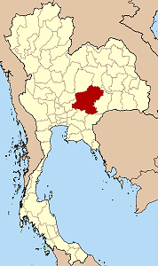
Map of Thailand highlighting Nakhon Ratchasima province

| This file is licensed under Creative Commons Attribution ShareAlike 1.0 License |
File history
Click on a date/time to view the file as it appeared at that time.
| Date/Time | Dimensions | User | Comment | |
|---|---|---|---|---|
| current | 12:58, 29 November 2004 | 178×300 (14 KB) | Ahoerstemeier | (Map of Thailand hightlighting Nakhon Ratchasima province {{GFDL}}{{cc-by-sa}}) |
File links
The following pages on the English Wikipedia link to this file (pages on other projects are not listed):
- Nakhon Ratchasima Province
- Phimai
- Ban Non Wat
- Amphoe Pak Chong
- Amphoe Dan Khun Thot
- Amphoe Thepharak
- Amphoe Sikhio
- Amphoe Bua Yai
- Amphoe Mueang Nakhon Ratchasima
- Amphoe Khon Buri
- Amphoe Soeng Sang
- Amphoe Khong
- Amphoe Pak Thong Chai
- Amphoe Chok Chai
- Amphoe Ban Lueam
- Amphoe Chakkarat
- Amphoe Wang Nam Khiao
- Amphoe Chaloem Phra Kiat, Nakhon Ratchasima Province
- Amphoe Non Thai
- Amphoe Non Daeng
- Amphoe Kaeng Sanam Nang
- Amphoe Huai Thalaeng
- Amphoe Prathai
- Amphoe Non Sung
- Amphoe Kham Sakaesaeng
- Amphoe Phimai
- Amphoe Nong Bun Mak
- Amphoe Sida
- Amphoe Bua Lai
- Amphoe Mueang Yang
- Amphoe Chum Phuang
- Amphoe Sung Noen
- Amphoe Kham Thale So
- Amphoe Phra Thong Kham
- Amphoe Lam Thamenchai
- Template:NakhonRatchasima-geo-stub
- Nakhon Ratchasima Metropolitan Area

