Talk:Regional Bell Operating Company
From Wikipedia, the free encyclopedia

One note... Verizon is spinning off its wireline services in Maine, New Hampshire, and Vermont -- merging them into Fairpoint.com, a company which operates several (smaller) local phone companies. Does this constitute a "new" RBOC? Here is a link regarding this: press release. I also see that Fairpoint Communications has no dedicated Wikipedia article just yet. (Wouldn't it be interesting if the new AT&T eventually bought Fairpoint?) padawer 23:59, 24 January 2007 (UTC)
Why is there no mention of South Central Bell? They later (around the early 90s) changed their name to Bellsouth. --tegsirat
Where did the Baby Bells result from? The article doesn't state, that the Baby Bells were formed from AT&T (as I think it happened) - the article just declares, that Baby Bells just happened to be in the 80s. --Abdull 08:55, 4 Mar 2005 (UTC)
- Baby bells came from the governments antitrust lawsuit against AT&T in 1984. The court ordered the companies to be split regionally, so that long distance companies like MCI could compete with AT&T-provided long distance. That should be included, yes... Cool Hand Luke 22:28, 4 Mar 2005 (UTC)
Contents |
[edit] Cincinnati Bell
The article and graphic seem to ignore the fact that Cincinnati Bell is still in existence.
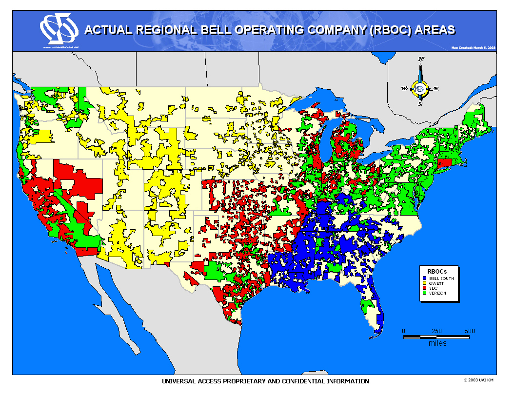
[edit] Misleading geographic coverages in map
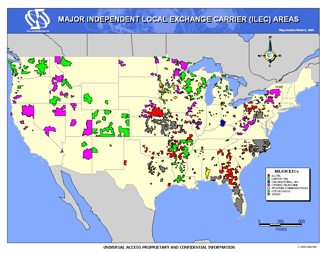
The state-boundary-resolution map in this article shows the old Bell Atlantic portion of Verizon along the east coast of the USA. This is somewhat misleading because Verizon is the local incumbent carrier in a fairly substantial portion of the Texas-to-Great-Lakes region labeled merely as AT&T. There are regions of downstate Illinois in particular where the density of Verizon/former-GTE/former-Centel is greater than the density of AT&T/former-SBC/former-Ameritech/former-Illinois-Bell. This is true as well for portions of northern Indiana and rural Texas. In this regard, the map is highly misleading because for some states (e.g., Virginia, Hawaii) there are few if any telephone companies other than the one designated on the map, whereas in Illinois, Indiana, Arkansas, and Texas in particular, there is vast areas of local-exchange-carrier (LEC) incumbency by Verizon and Alltel/former-Contel (as shown in green at http://www.alltel.com/corporate/media/downloads/usmaphires.jpg) in particular as well as a plethora of independents (as shown at http://www.directionsmag.com/images/mapgallery/172_lg.jpg which does not include Alltel and former-GTE Verizon). Especially revealing is http://www.directionsmag.com/images/mapgallery/173_lg.jpg, which clearly shows that AT&T/SBC/Ameritech/IllinoisBell is the ILEC for much less than half of the geographic area of Illinois once Verizon/GTE/Centel are removed and the still-existing numerous independents are removed. In fact in that last map, if one removes nationwide all of the white (independent LECs) and removes the nonBellAtlantic portion of Verizon (which would be the old GTE/Centel), one can clearly see how geographically concentrated the old Bell System was in the cities and how little of the total geography of USA had the Bell System as their local ILEC and in the end how misleading the broad state-boundary generalities are in the map of this article. optikos 07:59, 06 December 2005
[edit] RE: Misleading geographic coverages in map
The subject of the article is the RBOCs, Regional Bell Operating Companies. This does not cover GTE and other independents that existed completely seperate from AT&T as of December 31, 1983. Yes, Verizon owns GTE now but it doesn't make GTE territory "BELL" regions.
- So we agree that Hawaii is mislabeled as Verizon RBOC territory? Hawaii had no Hawaii Bell BOC that became part of an RBOC on 01 January 1984. Hawaii was an ILEC territory of neither Bell Atlantic nor NYNEX. Hawaii was predominantly-GTE ILEC territory until the GTE & Bell Atalntic merger that formed Verizon. (Plus the Carlyle Group ownership reason listed below further erodes the logic for labeling Hawaii as RBOC territory.) optikos 8:51, 11 December 2005
- My point is that the map purports to show an accurate representation of RBOC territory and it does not do so truthfully. The map shows each whole state as RBOC ILEC territory, which is thoroughly false now and was thorough false on 01 January 1984. Although showing a whole state might be fine for some states such as Delaware or Massachusetts where independent ILECs are little more than round-off-error noise as shown in http://www.directionsmag.com/images/mapgallery/173_lg.jpg, it is obvious in other states that BOCs/RBOCs controlled only a small fraction of the territory of the state. This map perpetuates a common misperception, especially among people who live in historically BOC/RBOC ILEC territory that Ma Bell and then the RBOCs supposedly had near-100% control of the ILEC space throughout USA (and Canada pre-1954). The map's perpetuation of this urban legend does a disservice to those people who come to this page for accurate information. (I say "urban" legend because Ma Bell's century of acquisitions and network expansions nearly fully executed the goal of being the ILEC for all major metropolitan areas, so it would require being exposed to life in a moderate-sized metropolitan area or smaller to know the truth that BOCs/RBOCs controlled far, far less ILEC territory than the people living in big urban areas would have us believe.) optikos 08:51, 11 December 2005
- I recently updated the map to express the changes in Hawaii and the forgotten addition of Cincinnati Bell. While, I understand your concerns that there are multiple companies that operate within the regional bell areas (and outside of them), I do not agree that the map is inaccurate. I simply think that it expresses how things were divided after the 1984 decision and how things have developed since due to mergers, etc. Though I understand the map is somewhat of a simplification, in my opinon it is a necessary one. Looking at the maps you provided links to, there is no way I am going to be able to recreate such a complicated map (so complicated in fact that it requires three maps to fully understand) with every single local phone company (with many areas having multiple carriers). If you want to create such a map for wikipedia (I have a feeling your linked maps are copy protected and therefore unsuitable for wikipedia), go right ahead and add or replace the map on the page. However, I am not going to waste my time with such an endeavor when I feel this map is easy to understand, and does a good job showing the generality of these companies service areas. Vertigo700 07:23, 12 December 2005 (UTC)
-
- Actually, this map doesn't fully represent any time period from 1984 to present. Counting the scattered GTE territories alone would make a messy picture. It troubles me that Cinncinati Bell is shown although the massive irregularities inherited from GTE alone (let alone the other LECs) are left out.
-
- I think the map is somewhat useful because it shows areas that the major LECs are primarily confined to. In this respect it's just a graphical way to list the states and their largest LECs. optikos has a good point about misleading readers, but I'm not sure whether the map does more harm than good. In any case, I'd also welcome a more detailed map. Cool Hand Luke 03:02, 13 December 2005 (UTC)
If we were to map every telephone company's territory, the map would be an abstract painting with a familiar outline. --Dial 23:46, 9 January 2007 (UTC)
-
- This is a big problem in my opinion, since BELLSOUTH doesn't even exist anymore. Can we remove the map or at least ask the original poster to put an "as of caption"? —Preceding unsigned comment added by Nicolaususry (talk • contribs) 23:30, 2 January 2008 (UTC)
[edit] Verizon Hawaii
Verizon does not provide telephone services in Hawaii anymore - they have been sold to The Carlyle Group to become Hawaiian Telcom.
- Furthermore, Verizon Hawaii was not former Bell Atlantic or NYNEX RBOC territory as of December 31, 1983 and thus does not qualify as true Bell Atlantic or NYNEX territory, because any GTE ILEC or independent ILEC territory that Verizon purchased after December 31, 1983 violates the rule stated in "RE: Misleading geographic coverages in map" section above. optikos 08:51, 11 December 2005
[edit] Page move
I propose that this page be moved back to Regional Bell operating company. "Bell" is a proper noun (Alexander Graham's last name), but "operating company" is not. See WP:NC. I will leave this notice up for discussion for a while, then post a notice on Wikipedia:Requested moves. --Russ Blau (talk) 17:19, 19 December 2005 (UTC)
I disagree with this. The term has become fully capitalized in nearly all usage. A quote from bell.com, which is the jointly-run (well mostly BellSouth) Bell site says "The Regional Bell Operating Companies ("RBOCs")". I would take their judgement, since they are (soon to be were?) one. --Warphammer 04:53, 20 April 2006 (UTC)
[edit] Lucent & Cincinnati Bell ?
Pardon my ignorance, but are Lucent and Cincinnati Bell represented by other names on that cool drawing?
Lucent was not a RBOC. Lucent - then still called Western Electric - was retained by AT&T until divested itself in the 90's, before its own fragmentation. --Warphammer 04:53, 20 April 2006 (UTC)
[edit] Merger
Should this page merge into with Bell System Divestiture? They hold similar content, but the Bell System Divestiture name is more appropriate. If this page should merge into Bell System Divestiture, then: Bell System Divestiture should be unstubized and Cincinnati Bell should be included on the map, since it was part of the Bell System--85.130.153.231 06:52, 27 June 2006 (UTC)
[edit] Redirect Notice
This page should have a redirect notice saying that Baby Bell redirects here, and give a link to Babybel. I have absolutely no idea how this is done, however. --Muna (talk) 10:22, 2 January 2008 (UTC)
- Use {{redirect|Baby Bell|Babybel cheese|Babybel}} Which makes a notice like this:
-
"Baby Bell" redirects here. For Babybel cheese, see Babybel.
- I doubt that people will make this mistake though. Do we really need this notice? Cool Hand Luke 10:29, 2 January 2008 (UTC)
- Babybel and Baby Bell are phonetically identical, and spellings are not always known (and Babybel is not a regular spelling, whereas Baby Bell is), for this reason, I think it is appropriate. However, I'm not going to add the redirect notice while it is opposed. --Muna (talk) 00:21, 3 January 2008 (UTC)

