Monhegan, Maine
From Wikipedia, the free encyclopedia
| Monhegan, Maine | |
 |
|
 Monhegan, Maine
|
|
| Coordinates: | |
|---|---|
| Country | United States |
| State | Maine |
| County | Lincoln |
| Incorporated | 1839 |
| Area | |
| - Total | 4.5 sq mi (11.7 km²) |
| - Land | 0.9 sq mi (2.2 km²) |
| - Water | 3.7 sq mi (9.5 km²) |
| Elevation | 0 ft (0 m) |
| Population (2000) | |
| - Total | 75 |
| - Density | 87.5/sq mi (33.8/km²) |
| Time zone | Eastern (EST) (UTC-5) |
| - Summer (DST) | EDT (UTC-4) |
| ZIP code | 04852 |
| Area code(s) | 207 |
| FIPS code | 23-46335 |
| GNIS feature ID | 0582600 |
Monhegan is an island and community in Lincoln County, Maine, United States, about 12 nautical miles off the coast. As of the 2000 census, the island had a total year-round population of 75, although it swells to about 1,200 during the summer. The municipality is organized as a plantation, which in Maine typically indicates an organized governmental status falling between township (unorganized territory) and town. The island is accessible by mailboat ferry (no automobiles) from Boothbay Harbor, New Harbor and Port Clyde.
Contents |
[edit] History
The name Monhegan derives from Monchiggon, Algonquian for "out-to-sea island." European explorers Martin Pring visited in 1603, Samuel de Champlain in 1604, George Weymouth in 1605 and Captain John Smith in 1614. The island got its start as a British fishing camp prior to settlement of the Plymouth Colony. Cod was harvested from the rich fishing grounds of the Gulf of Maine, then dried on fish flakes before shipment to Europe. A trading post was built to conduct business with the Indians, particularly in the lucrative fur trade. It was Monhegan traders who taught English to Samoset, the sagamore who in 1621 startled the Pilgrims by boldly walking into their new village at Plymouth and saying: "Welcome, Englishmen."
Despite success as a fishing and trade center, Monhegan would be caught in the conflict between New England and New France for control of the region. During King Philip's War, dispossessed English settlers from the mainland sought refuge on the island before being relocated elsewhere along the coast. During King William's War, the island was captured for the French in 1689 by Baron de Saint-Castin. He destroyed the fishing fleet and burned the buildings, with many inhabitants escaping to Massachusetts. But even during periods when Monhegan was abandoned, its convenient offshore harbor remained a stopover destination for ships. The conclusion of the French and Indian War in 1763 brought peace to the area, and on September 4, 1839, Monhegan was incorporated as an island plantation.
In 1824, a conical stone lighthouse was built on the island by order of Congress and President James Monroe. Damaged by storms, it was replaced in 1850 by the present 48 foot (14.6 meter) granite tower, with a fog bell station built in 1855 on nearby Manana Island. The island's 1,000 acres (400 hectares) of good land encouraged agriculture, with potatoes the chief crop. But fishing was always the most important industry, whether locally or at the Grand Banks. Today, it still dominates Monhegan’s economy. From December through May, fishermen harvest lobsters from the only lobster conservation area in the state of Maine.
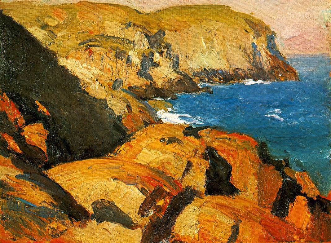
Summer months bring artists and tourists on a daily ferry to see amazing ocean views and migrating island birds. Much of Monhegan is uninhabited and free to explore on 17 miles (24 kilometers) of dirt hiking trails. Monhegan only recently installed its own source of electricity; the island is still widely regarded as quaint and unspoiled. The beginnings of the art colony on Monhegan date to the mid-19th century; by 1890, it was firmly established. Among many prominent artists who have have found inspiration on the island are Edward Hopper and Rockwell Kent, both of whom painted the 150 foot (50 meter) northside cliffs at Blackhead:
[edit] Notable residents and semi-residents

- George Bellows, artist
- Jon Bogdanove, comic book artist
- Kate Chappell, businesswoman
- Tom Chappell, businessman
- Edward Hopper, artist
- Rockwell Kent, artist
- Josh Mostel, actor
- Zero Mostel, actor
- Sonya Sklaroff, artist
- Andrew Wyeth, artist
- Jamie Wyeth, artist
- N. C. Wyeth, artist
- Zoe Zanidakis, Survivor: Marquesas 8th place finisher
[edit] Geography
According to the United States Census Bureau, the plantation has a total area of 4.5 square miles (11.7 km²), of which, 0.9 square miles (2.2 km²) of it is land and 3.7 square miles (9.5 km²) of it (80.97%) is water. Monhegan is an island 1.75 miles (2.8 kilometers) long and .75 of a mile (1.2 kilometers) wide located in the Gulf of Maine, part of the Atlantic Ocean. Adjacent Manana Island helps form Monhegan Harbor.
[edit] Demographics
As of the census[1] of 2000, there were 75 people, 46 households, and 21 families residing in the plantation. The population density was 87.5 people per square mile (33.7/km²). There were 177 housing units at an average density of 206.4/sq mi (79.5/km²). The racial makeup of the plantation was 97.33% White and 2.67% Asian.
There were 46 households out of which 13.0% had children under the age of 18 living with them, 32.6% were married couples living together, 4.3% had a female householder with no husband present, and 54.3% were non-families. 47.8% of all households were made up of individuals and 4.3% had someone living alone who was 65 years of age or older. The average household size was 1.63 and the average family size was 2.24.
In the plantation the population was spread out with 10.7% under the age of 18, 8.0% from 18 to 24, 29.3% from 25 to 44, 37.3% from 45 to 64, and 14.7% who were 65 years of age or older. The median age was 48 years. For every 100 females there were 127.3 males. For every 100 females age 18 and over, there were 116.1 males.
The median income for a household in the plantation was $26,250, and the median income for a family was $53,125. Males had a median income of $36,563 versus $13,333 for females. The per capita income for the plantation was $20,568. There were 10.5% of families and 3.8% of the population living below the poverty line, including 10.0% of under eighteens and none of those over 64.
[edit] Sites of interest
[edit] References
- History of Monhegan Plantation, Maine (1886)
- A. J. Coolidge & J. B. Mansfield, A History and Description of New England, 1859; H. O. Houghton and Company, printers; Cambridge, Massachusetts
- A Century of Monhegan Art
[edit] External links
- Monhegan Commons
- Monhegan Info
- Visitors' Guide
- Monhegan Associates
- The Island Inn
- Maine.gov -- Plantation of Monhegan Island, Maine
- US Census 2000 Monhegan Plantation
|


