Image:Ireland map County Clare Magnified.png
From Wikipedia, the free encyclopedia
No higher resolution available.
Ireland_map_County_Clare_Magnified.png (188 × 244 pixels, file size: 10 KB, MIME type: image/png)
| | This is a file from the Wikimedia Commons. The description on its description page there is shown below.
|
| This map image was uploaded in a raster image format such as PNG, GIF, or JPEG. However, it contains information that could be stored more efficiently and/or accurately in the SVG format, as a vector graphic. If possible, please upload an SVG version of this image. After doing so, please replace all instances of the previous version throughout Wikipedia (noted under the “File links” header), tag the old version with {{Vector version available|NewImage.svg}}, and remove this tag. For more information, see Wikipedia:Preparing images for upload. For assistance with converting to SVG, please see the Graphics Lab. |
 |
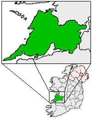
Ireland Map with County Clare Magnified.

File history
Click on a date/time to view the file as it appeared at that time.
| Date/Time | Dimensions | User | Comment | |
|---|---|---|---|---|
| current | 04:36, 21 May 2005 | 188×244 (10 KB) | Bastique | (Ireland Map with County Clare Magnified. {{GFDL}} Category:Maps of Ireland ) |
File links
The following pages on the English Wikipedia link to this file (pages on other projects are not listed):
- Inagh
- Ennis
- Shannon, County Clare
- Lisdoonvarna
- Cratloe
- Kilfenora
- Ballyvaughan
- Carran
- Kilkee
- Kilrush
- Clarecastle
- Ennistymon
- Killaloe, County Clare
- Lahinch
- Mountshannon
- Newmarket-on-Fergus
- O'Briensbridge
- Spanish Point
- Aughinish
- Scarriff
- Wikipedia:Irish Wikipedians' notice board/map gallery
- Corofin, County Clare
- Hurlers Cross
- Tuamgraney
- O'Briensbridge-Montpelier
- Cree (Creegh)
- Carrigaholt
- Miltown Malbay
- Whitegate, County Clare
- Ogonnelloe
- Inch, County Clare
- Mullaghmore, County Clare
- Tubber, Ireland
- Sixmilebridge
- O'Callaghans mills
- Ruan, County Clare

