Image:European Middle Neolithic.gif
From Wikipedia, the free encyclopedia
Size of this preview: 800 × 402 pixels
Full resolution (1,320 × 663 pixels, file size: 104 KB, MIME type: image/gif)
| | This is a file from the Wikimedia Commons. The description on its description page there is shown below.
|
| Description |
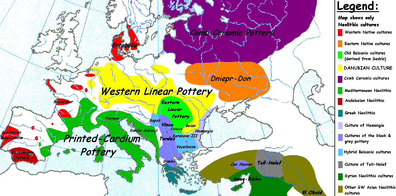
English: Map of the second half European Middle Neolithic at the apogee of Danubian and Mediterranean expansion.
(The modification of the original map - Combed pottery, earlier notated as Pitted Ware, see history without respecting the color code of the legend is something that I am not fully satisfied with). |
|---|---|
| Source |
Originally from en.wikipedia; description page is/was here. |
| Date |
2005-04-05 (first version); 2005-08-28 (last version) |
| Author |
Original uploader was Sugaar at en.wikipedia Later versions were uploaded by Clarifer at en.wikipedia. |
| Permission (Reusing this image) |
PD-SELF. |
| Maps of the history of Europe | |
| BC aC |
Middle Neolithic · Late Neolithic · 220 |
|
|
|
| AD dC |
60 · 395 · 400 · 450 · 476 · 526 · 526-600 · 800 · 814 · 843-870 · 998 · 1000 · 1092 · 1097 · 1142 · 1190 · 1328 · 1360 · C.15 · 1430 · 1470 · 1490 · 1550 · 1648 · 1700 · 1708 · 1740 · 1812 · 1814 · 1815 · 1890 · 1905 · 1911 · 1914-24 · 1919-29 · 1941-42 · 1942-45 · 1945-89 · 1993-2006 · 2006 to date |
| (this template: · view · discuss ) | |
[edit] License information
| This image has been (or is hereby) released into the public domain by its author, Sugaar at the English Wikipedia project. This applies worldwide. In case this is not legally possible: |
[edit] Original upload log
(All user names refer to en.wikipedia)
- 2005-08-28 13:11 Clarifer 1320×663×8 (106148 bytes) Added the approximate area of the Comb Ceramic culture. Source: National Board of Antiquities, Finland. www.nba.fi
- 2005-04-05 20:12 Sugaar 1320×663×8 (103228 bytes) Map of the second half European Middle Neolithic at the apogee of Danubian and Mediterranean expansion (c. 4500-4000 BCE). Made by [[Sugaar]]. Free use authorized by the author.
File history
Click on a date/time to view the file as it appeared at that time.
| Date/Time | Dimensions | User | Comment | |
|---|---|---|---|---|
| current | 00:50, 14 February 2007 | 1,320×663 (104 KB) | 32X | (Auf eine alte Version zurückgesetzt) |
| 00:49, 14 February 2007 | 1,320×663 (101 KB) | 32X | (Original version by Sugaar.) | |
| 11:14, 31 December 2005 | 1,320×663 (104 KB) | Glenn | (Originally uploaded to en-wiki: Quote: "Map of the second half European Middle Neolithic at the apogee of Danubian and Mediterranean expansion (c. 4500-4000 BCE)." Upload text: "20:12, 5 April 2005 . . Sugaar . . 1320x663 (103228 bytes) (Map of the secon) |
File links
- Neolithic
- Finnic peoples
- Vinča culture
- Neolithic Europe
- Old European culture
- Starčevo culture
- Ertebølle culture
- History of Eurasia
- Comb Ceramic culture
- Prehistoric Europe
- User:Sugaar
- Linear Pottery culture
- Prehistoric France
- Prehistoric Romania
- Bug-Dniester culture
- Bükk Culture
- Broad homeland hypothesis

