From Wikipedia, the free encyclopedia
1992 Pacific typhoon season
| First storm formed: |
January 5, 1992 |
| Last storm dissipated: |
December 1, 1992 |
| Strongest storm: |
Super Typhoon Gay - 160 kn (300 km/h) (1-min), 872 mbar |
| Total storms: |
32 (including one Central Pacific storm, Ekeka) |
| Typhoons: |
21 |
| Super typhoons: |
5 |
| Total fatalities: |
|
|
|
The 1992 Pacific typhoon season had no official bounds; it ran year-round in 1992. Despite this, most tropical cyclones tend to form in the northwestern Pacific Ocean between May and November.[1] These dates conventionally delimit the period of each year when most tropical cyclones form in the northwestern Pacific Ocean.
The scope of this article is limited to the Pacific Ocean, north of the equator and west of the International Date Line. Storms that formed north of the equator and east of the Date Line in 1992 are part of the 1992 Pacific hurricane season. In the West Pacific basin, tropical depressions have the "W" suffix added to their number. Storms reaching tropical storm intensity of 34 kn (63 km/h) sustained winds were assigned a name by the Joint Typhoon Warning Center (JTWC). Storms with sustained winds exceeding 64 knots (119 km/h) are called typhoons, while intense typhoons with sustained winds exceeding 130 knots (240 km/h) are designated super typhoons by the JTWC (see tropical cyclone scales).
Furthermore, tropical depressions that enter or form in the Philippine Area of Responsibility are assigned an internal name by the Philippine Atmospheric, Geophysical and Astronomical Services Administration (PAGASA). This can often result in the same storm having two names.
[edit] Storms
There were a total of 33 tropical cyclones in the Western Pacific in 1994. 32 of these formed within the basin, and 1 storm, Tropical Storm Ekeka, formed in the Central Pacific basin, crossing the Date Line to enter the Western Pacific. Out of the 33, 32 became named tropical storms, 21 reached typhoon intensity, and 5 reached super typhoon strength. Storms are listed in numerical ascending order by their JTWC tropical depression numbers except for Ekeka, and not in alphabetical order of names. Thus, Tropical Storm Zack (22W) is listed before Super Typhoon Yvette (23W).
[edit] Typhoon Axel
[edit] Tropical Storm Ekeka
[edit] Typhoon Bobbie
[edit] Typhoon Chuck
When 90 mph (140 km/h) Typhoon Chuck hit southern Hainan Island and northern Vietnam on June 28 and 29, it brought heavy flooding amounting to 40 casualties.
[edit] Tropical Storm Deanna
[edit] Typhoon Eli (Konsing)
[edit] Tropical Storm Faye
[edit] Typhoon Gary
23 fatalities and $148 million (1992 USD) in damage can be attributed to Typhoon Gary hitting southern China on July 22.
[edit] Tropical Storm Helen
[edit] Typhoon Irving
[edit] Typhoon Janis
[edit] Super Typhoon Kent
[edit] Tropical Storm Lois
[edit] Tropical Storm Mark
[edit] Tropical Storm Nina
[edit] Super Typhoon Omar (Lusing)
- Main article: Typhoon Omar
Typhoon Omar was a destructive storm to Guam, causing over a foot of rain to Guam, amounting to $457 million in damage (1992 USD) but no deaths. In Taiwan, the storm caused 2 deaths and heavy rainfall. The name Omar was retired after this season.
[edit] Tropical Storm Polly
Developing to Omar's west, Polly began its life on August 23 and reached tropical storm strength on the 26th. As a developing monsoon depression, it had a large outflow. Polly retained that throughout its lifetime, inhibiting intensification past 60 mph (97 km/h) winds. On the 30th, the storm hit southeastern Taiwan, and on the 31st it hit China. Polly caused torrential rains resulting in 173 casualties.
[edit] Typhoon Ryan
[edit] Typhoon Sibyl
[edit] Typhoon Ted
Tropical Storm Ted, having developed on September 14, stalled off northern Luzon on the 20th. It turned northward, and hit southern Taiwan on the 22nd as a minimal typhoon. Ted weakened to a tropical storm over the island, and hit eastern China on the 23rd. It turned to the northeast, hit South Korea, and became extratropical on the 24th. Ted brought heavy flooding, resulting in 71 fatalities.
[edit] Tropical Storm Val
[edit] Typhoon Ward
[edit] Tropical Storm Zack
[edit] Super Typhoon Yvette
[edit] Typhoon Angela
[edit] Typhoon Brian
[edit] Typhoon Colleen
[edit] Typhoon Dan
[edit] Super Typhoon Elsie
[edit] Tropical Depression 29W
On October 30, a tropical disturbance began to form west of the International Date Line. The JTWC then issued a Tropical Cyclone Formation Alert late the next day as the system moved westward and started warnings on Tropical Depression 29W on November 1. However, intensification was severely inhibited by outflow from nearby Typhoon Dan, and the depression failed to develop. It passed within 30 nm (55 km) of Wake Island, causing a minor pressure dip and gusts to 32 kt (60 km/h). No damage was reported, due to the relative weakness of 29W as compared to Dan, which ravaged the island 3 days earlier. The depression dissipated on November 2 over open ocean.[2]
[edit] Tropical Storm Forrest
On November 8 a tropical depression formed from the monsoon trough east of the Philippines. It crossed the islands, and strengthened to a tropical storm in the South China Sea on the 12th. Forrest continued westward until hitting and crossing the Malay Peninsula on the 15th. It reached a peak of 145 mph (233 km/h) winds in the Bay of Bengal before hitting Myanmar on the 21st. Its history in the Indian Ocean can be found in its seasonal article.
[edit] Super Typhoon Gay
Typhoon Gay was the strongest typhoon of the season (indeed there appears to be some debate as to whether it surpassed the record intensity of Super Typhoon Tip[3]), Gay reached peak winds of 185 mph (298 km/h) winds over the open Western Pacific in mid-November, and went on to threaten the Marina islands at peak strength, but weakened greatly due to interaction with Typhoon Hunt thus causing a surprisingly low death toll over the Marianas Islands with moderate damage.[4]
[edit] Typhoon Hunt
[edit] Other storms
[edit] Storm names
Tropical cyclones in the Western North Pacific were named by the JTWC. The first storm of 1992 was named Axel and the final one was named Hunt. The name Omar was retired after this season and replaced by Oscar.
- Angela 24W
- Brian 25W
- Colleen 26W
- Dan 27W
- Elsie 28W
- Forrest 30W
- Gay 31W
- Hunt 32W
-
Irma
-
Jack
-
Koryn
-
Lewis
-
Marian
-
Nathan
-
Ofelia
-
Percy
-
Robyn
-
Steve
-
Tasha
-
Vernon
-
Winona
-
Yancy
-
Zola
|
-
Abe
-
Becky
-
Cecil
-
Dot
-
Ed
-
Flo
-
Gene
-
Hattie
-
Ira
-
Jeana
-
Kyle
-
Lola
-
Manny
-
Nell
-
Owen
-
Page
-
Russ
-
Sharon
-
Tim
-
Vanessa
-
Walt
-
Yunya
-
Zeke
|
-
Amy
-
Brendan
-
Caitlin
-
Doug
-
Ellie
-
Fred
-
Gladys
-
Harry
-
Ivy
-
Joel
-
Kinna
-
Luke
-
Melissa
-
Nat
-
Orchid
-
Pat
-
Ruth
-
Seth
-
Teresa
-
Verne
-
Wilda
-
Yuri
-
Zelda
|
- Axel 01W
- Bobbie 02W
- Chuck 03W
- Deanna 04W
- Eli 05W
- Faye 06W
- Gary 07W
- Helen 08W
- Irving 09W
- Janis 10W
- Kent 11W
- Lois 12W
- Mark 13W
- Nina 14W
- Omar 15W
- Polly 16W
- Ryan 17W
- Sibyl 18W
- Ted 19W
- Val 20W
- Ward 21W
- Yvette 23W
- Zack 22W
|
One storm which formed in the Central Pacific basin, Hurricane Ekeka (01C), crossed into the Western Pacific basin as a tropical storm, keeping its original name and "C" suffix.
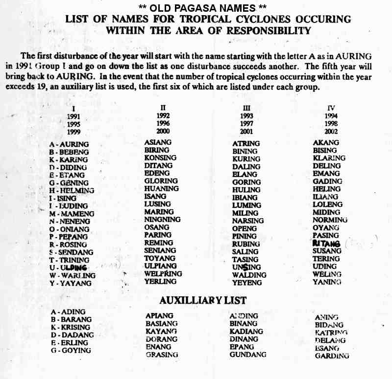
The Philippine Atmospheric, Geophysical and Astronomical Services Administration (PAGASA) used its own naming scheme for tropical cyclones within its area of responsibility. Lists were recycled every four years. This was the list set for 1992.[5] This is the same list used for the 1988 season, except for Ulpiang, which replaced Unsang.
- Asiang
- Biring
- Konsing 05W
- Ditang
- Edeng
|
- Gloring
- Huaning
- Isang
- Lusing 15W
- Maring
|
- Ningning
- Osang
- Paring
- Reming
- Seniang
|
- Toyang
- Ulpiang
- Welpring
- Yerling
- Apiang
|
- Basiang
- Kayang
- Dorang
- Enang
- Grasing
|
[edit] References
[edit] See also
[edit] External links


.JPG/150px-Typhoon_Gay_(1992).JPG)


