From Wikipedia, the free encyclopedia
The 1991 Pacific typhoon season has no official bounds; it ran year-round in 1991, but most tropical cyclones tend to form in the northwestern Pacific Ocean between May and November.[1] These dates conventionally delimit the period of each year when most tropical cyclones form in the northwestern Pacific Ocean.
The scope of this article is limited to the Pacific Ocean, north of the equator and west of the international date line. Storms that form east of the date line and north of the equator are called hurricanes; see 1991 Pacific hurricane season. Tropical Storms formed in the entire west pacific basin were assigned a name by the Joint Typhoon Warning Center. Tropical depressions in this basin have the "W" suffix added to their number. Tropical depressions that enter or form in the Philippine area of responsibility are assigned a name by the Philippine Atmospheric, Geophysical and Astronomical Services Administration or PAGASA. This can often result in the same storm having two names.
[edit] Storms
31 tropical cyclones formed this year in the Western Pacific, of which 29 became tropical storms. 20 storms reached typhoon intensity, of which 5 reached super typhoon strength.
[edit] Tropical Storm Sharon
[edit] Typhoon Tim
[edit] Tropical Storm Vanessa
[edit] Super Typhoon Walt
[edit] Typhoon Yunya
After a month without activity in the Western Pacific, a weak tropical depression (with winds of only 10 knots) developed just east of the Philippines and south of the Tropical Upper Tropospheric Trough on June 11. Located in an area of little wind shear, it headed northwestward, developing spiral-band outflow and becoming a tropical storm on the 12th. As a small central dense overcast (CDO) developed over Yunya, it rapidly developed, becoming a typhoon on the 13th as it paralleled the eastern Philippines. The mid-level ridge forced Yunya westward, where it briefly reached a peak intensity of 120 mph (195 km/h) winds on the 14th. Subsequently, the eastward building of the subtropical ridge produced unfavorable vertical wind shear that weakened Yunya to a minimal typhoon before hitting Dingalan Bay, Luzon early on the 15th. Yunya left Luzon as a minimal tropical storm at Lingayen Gulf. It turned northward due to a break in the ridge, and dissipated on the 17th near southern Taiwan due to the vertical shear.
Yunya would normally have been an uneventful cyclone, but on the day it hit Luzon, the colossal eruption of Mount Pinatubo took place. The ash cloud that normally would have been dispersed across the oceans was redistributed over Luzon by the cyclonic winds of the typhoon, greatly exacerbating the damage caused by the eruption. The water-laden ash fell over the evacuated Clark Air Base, as well as the rest of Luzon, resulting in downed power lines and the collapse of flat-roofed buildings. In some areas it was practically raining mud.
Yunya exited Luzon through the Lingayen Gulf as a weak tropical storm and then turned north toward a break in the subtropical ridge. The system continued to weaken due to the strong vertical wind shear. It then brushed the southern coast of Taiwan as a tropical depression and finally dissipated before it could complete full recurvature into the mid-latitude westerlies. Yunya directly caused one death from the flooding and heavy rainfall it left.[3]
[edit] Typhoon Zeke
[edit] Typhoon Amy
145 mph (233 km/h) Typhoon Amy, having developed on July 12 over the open Western Pacific, brushed southern Taiwan on the 18th. Its outflow became restricted, and Amy hit southern China on the 19th as a 120 mph (190 km/h) typhoon. It caused heavy flooding, resulting in 99 casualties, 5000 people injured, and 15,000 people homeless. In addition, Amy caused the sinking of the freighter Blue River, resulting in an additional 31 deaths.
[edit] Typhoon Brendan
On July 22, minimal Typhoon Brendan hit northern Luzon, causing additional flooding to an area devastated by the Mount Pinatubo eruption and Typhoon Yunya. Brendan continued to the west-northwest, and hit southeastern China near Macau on the 24th. The typhoon caused 15 feet (4.6 m) high mudflows on Luzon, resulting in 3 fatalities and moderate damage. When Brendan's flooding combined with abnormally high spring and summer rainfall in China, over 100 additional casualties occurred.
[edit] Typhoon Caitlin
Typhoon Caitlin developed from a disturbance in the eastern Caroline Islands. A tropical depression formed on July 23th as the system moved towards the northwest. Tropical Storm Caitlin was named the on the 24th and was upgraded to a typhoon the next day. Typhoon Caitlin though several hundred miles away increased the monsoonal flow over the Philippines. Heavy rains caused landslides in the Mt. Pinatubo region killing 16 people. As Caitlin turned to the north the storm passed 60 miles (97 km) to the west of Kadena AB,Okinawa at peak intensity of 110 mph.. The heavy rains from Caitlin helped to relieve the ongoing drought on the island, one death was reported. Typhoon Caitlin then began to accelerate northwards and passed through the Korea Strait before turning extratropical in the Sea of Japan. Heavy flooding in South Korea killed 2 people and caused $4 million in damage.[4]
[edit] Tropical Storm Doug
[edit] Typhoon Ellie
[edit] Typhoon Fred
Typhoon Fred organized from a monsoon trough situated to the east of the Central Philippines, a depression formed on the 11th of August. The depression moved across northern Luzon Island, upon entering the South China Sea the depression was upgraded to Tropical Storm Fred. Fred reached typhoon intensity on the 14th of August as the storm moved south of Hong Kong. Typhoon Fred reached peak intensity of 110 mph (180 km/h) shortly before moving across Hainan Island. Fred then turned to the southwest across the Gulf of Tonkin and made a final landfall in northern Vietnam before dissipating. As Typhoon Fred moved south of Hong Kong the oil exploration vessel Derrick Barge sank with 195 people on board, 22 people onboard the ship were killed. On Hainan Island heavy flooding and landslides from Fred's rains killed 16 people.[5]
[edit] Typhoon Gladys
Minimal typhoon Gladys brushed by southern Japan on August 22. It moved to the northwest, and hit the Korean Peninsula on the 23rd. It caused more than 20 million yen of damage in Japan, more than 270 million won of damage in South Korea, and in South Korea, it left 103 dead or missing and more than 20,000 homeless.
[edit] Tropical Storm Harry
[edit] Typhoon Ivy
Typhoon Ivy formed from a broad monsoon trough situated near Kosrae in the eastern Caroline Islands. A tropical depression formed on the 2nd of September as the system moved towards the northwest, the next day the depression strengthened into Tropical Storm Ivy. Ivy began to rapidly intensify and reached typhoon strength as the storm passed 130 miles (210 km) east of Tinian and Saipan in the Northern Mariana Islands. On Saipan one drowning death was reported, but only minor damage was reported in the Northern Marianas. Typhoon Ivy continued on a northwesterly path and reached peak strength of 130 mph (210 km/h) on the 7th of September prior to recurving to the northeast. Ivy paralleled the southeastern Japan coastline and turned extratropical 600 miles (970 km) to the east of Tokyo. As Typhoon Ivy made it's closest approach to Honshū Island, Tokyo and surrounding areas were buffeted by high winds and heavy rains. Over 200 landslides were reported and one person was killed with 4 others missing. [6]
[edit] Tropical Storm Joel
[edit] Typhoon Kinna
Typhoon Kinna formed in a monsoon trough in the western Caroline Islands a tropical depression began to organize on the 10th of September to the west of Guam, Tropical Storm Kinna was named later the same day. As Kinna moved towards the northwest the storm began to gather strength and reached typhoon intensity on the 12th of September just prior to turning north threatening Japan. On the 12th Typhoon Kinna made a direct landfall on southern Okinawa Island at peak strength of 105 mph (169 km/h). Kinna maintained peak intensity after recurving to the north-northeast and making landfall on Kyūshū Island. Typhoon Kinna's eyewall passed directly over Nagasaki and Sasebo cities on the 13th of September, both cities reported wind gusts of 115 mph (185 km/h). Kinna continued moving across Japan and became extratropical near the northern coast of Honshū Island. On Okinawa Kinna dropped more than 8 inches (200 mm) of rain, in Japan most of the damage occurred near Nagasaki. Throughout Japan and Okinawa 9 deaths were attributable to Typhoon Kinna's passage.[7]
[edit] Tropical Storm Luke
Tropical Storm Luke formed from a disturbance that moved through the Northern Marianas and formed a depression on the 14th of September just to the west of the islands. The depression began to slowly intensify as it moved towards the west-northwest and Tropical Storm Luke was named on the 15th of September. Luke reached peak intensity of 60 mph (97 km/h) prior to recurving to the northeast and weakening due to increased shear. Tropical Storm Luke then paralleled the southeastern Japan coastline, dropping heavy rains. The resulting flooding and landslides killed 8 people and left 10 others missing prior to Luke turning extratropical east of central Honshū Island.[8]
[edit] Super Typhoon Mireille
- Main article: Typhoon Mireille
On September 13, Tropical Depression 21W developed over the open Western Pacific. It tracked westward under the influence of the Subtropical Ridge, slowly organizing until becoming a tropical storm on the 15th. A small storm, Mireille rapidly became a typhoon on the 16th, but larger Tropical Storm Luke to its north and Typhoon Nat to its west kept Mireille a minimal typhoon. When the other 2 storms were far enough away, Mireille rapidly intensified, reaching Super Typhoon strength on the 22nd with a peak of 150 mph (240 km/h) winds. The storm recurved to the northeast, where it slowly weakened until hitting southwestern Japan on the 27th as a 105 mph (169 km/h) typhoon. Mireille continued to the northeast, and became extratropical later that day, after causing 52 casualties and heavy crop damage amounting to $3 billion (1991 USD). The name Mireille was retired after this season and was replaced by Melissa.
[edit] Typhoon Nat
[edit] Typhoon Orchid
Typhoon Orchid formed from a broad monsoon trough that moved through the Northern Marianas and formed a depression on the 4th of October to the west of the islands. The depression moved on a westerly path and strengthened into Tropical Storm Orchid later the same day. Orchid then began to rapidly intensify and reach peak strength on 130 mph (210 km/h) on the 7th of October prior to turning to the northeast and accelerating. Typhoon Orchid paralleled the southeast coast of Shikoku and Honshū Islands. As Orchid brushed the islands 96 landslides and heavy flooding were reported in and around the Tokyo region, one person was reported killed due to flooding. Though a great distance away the waves from Orchid and Typhoon Pat combined to produced tremendous waves resulting in the deaths of 2 people on Guam.[9]
[edit] Typhoon Pat
[edit] Super Typhoon Ruth
Super Typhoon Ruth formed from a tropical disturbance the originated between Chuuk and Pohnpei, as the disturbance moved on a westerly path a tropical depression formed on the 20th of October. Tropical Storm Ruth was named on the 21st as the storm moved to the southwest of Guam and began to steadily intensity. Ruth reached typhoon strength on the 22nd of October and became a Super Typhoon on the 24rd as the storm reached peak intensity of 165 mph (266 km/h). Super Typhoon Ruth began to slowly decline in strength as it neared the northern Philippines. Typhoon Ruth made landfall on the 27th of October on northern Luzon Island with winds of 115 mph (185 km/h) before weakening to a tropical storm. Heavy flooding and numerous landslides were reported on Luzon Island as a result 12 people were killed. After departing Luzon Island Tropical Storm Ruth recurved south of Taiwan and dissipated. Heavy seas caused the freighter Tung Lung to sink west of Taiwan, all 18 aboard were killed.[10]
[edit] Super Typhoon Seth
[edit] Tropical Storm Thelma (Uring)
- Main article: Tropical Storm Thelma
50 mph (80 km/h) Tropical Storm Thelma hit the central Philippines on November 4. It slowly tracked across the Archipelago, bringing heavy flooding across the islands. Vertical shear weakened it as it continued westward, and it dissipated on November 8 just after hitting southern Vietnam. Thelma, though a weak storm, caused dam failures, landslides, and flash flooding, resulting in a horrendous death toll of 6,000 people.
[edit] Tropical Storm Verne
[edit] Tropical Storm Wilda
[edit] Super Typhoon Yuri
Super Typhoon Yuri was the most powerful storm during the season, with winds reaching up to 150 knots (278 km/h), and a minimum recorded pressure of 885 mbar. This made Yuri the third most intense tropical cyclone on record at the end of 1991; it now ranks as the 11th most powerful. Yuri caused $3 million (1991 USD) in damage to Pohnpei, including the loss of a radio tower. In Guam, the storm caused extensive beach erosion and destroyed between 60 and 350 buildings. There, damage totaled to $33 million (1991 USD).[11]
[edit] Typhoon Zelda
[edit] Storm names
Western North Pacific tropical cyclones were named by the Joint Typhoon Warning Center. The first storm of 1991 was named Sharon and the final one was named Zelda. The names Mireille and Thelma were retired after this season.
-
Angela
-
Brian
-
Colleen
-
Dan
-
Elsie
-
Forrest
-
Gay
-
Hunt
-
Irma
-
Jack
-
Koryn
-
Lewis
-
Marian
-
Nathan
-
Ofelia
-
Percy
-
Robyn
-
Steve
-
Tasha
-
Vernon
-
Winona
-
Yancy
-
Zola
|
-
Abe
-
Becky
-
Cecil
-
Dot
-
Ed
-
Flo
-
Gene
-
Hattie
-
Ira
-
Jeana
-
Kyle
-
Lola
-
Manny
-
Nell
-
Owen
-
Page
-
Russ
- Sharon 1W
- Tim 2W
- Vanessa 3W
- Walt 4W
- Yunya 5W
- Zeke 6W
|
- Amy 7W
- Brendan 8W
- Caitlin 9W
- Doug 10W
- Ellie 11W
- Fred 12W
- Gladys 14W
- Harry 16W
- Ivy 17W
- Joel 18W
- Kinna 19W
- Luke 20W
- Mireille 21W
- Nat 22W
- Orchid 23W
- Pat 24W
- Ruth 25W
- Seth 26W
- Thelma 27W
- Verne 28W
- Wilda 29W
- Yuri 30W
- Zelda 31W
|
-
Axel
-
Bobbi
-
Chuck
-
Deanna
-
Eli
-
Faye
-
Gary
-
Helen
-
Irving
-
Janis
-
Kent
-
Lois
-
Mark
-
Nina
-
Omar
-
Polly
-
Ryan
-
Sibyl
-
Ted
-
Val
-
Ward
-
Yvette
-
Zack
|
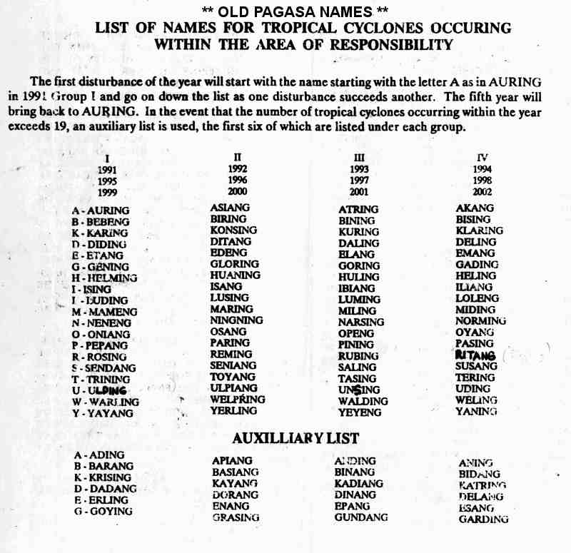
The Philippine Atmospheric, Geophysical and Astronomical Services Administration (PAGASA) used its own naming scheme for tropical cyclones within its area of responsibility. Lists were recycled every four years. This was the list set for 1991.[12] This is the same list used for the 1987 season, with the exception of Karing, Helming and Sendang which replaced Katring, Herming and Sisang. The name Uring was retired after this year and was replaced by Ulding.
- Auring
- Bebeng
- Karing
- Diding
- Etang
|
- Gening
- Helming
- Ising
- Luding
- Mameng
|
- Neneng
- Oniang
- Pepang
- Rosing
- Sendang
|
- Trining
- Uring
- Warling
- Yayang
- Ading
|
- Barang
- Krising
- Dadang
- Erling
- Goying
|
[edit] References
[edit] See also
[edit] External links


