Image:WW2-Holocaust-Europe-2007Borders.png
From Wikipedia, the free encyclopedia
Size of this preview: 721 × 600 pixels
Full resolution (1,310 × 1,090 pixels, file size: 767 KB, MIME type: image/png)
| | This is a file from the Wikimedia Commons. The description on its description page there is shown below.
|
[edit] Summary
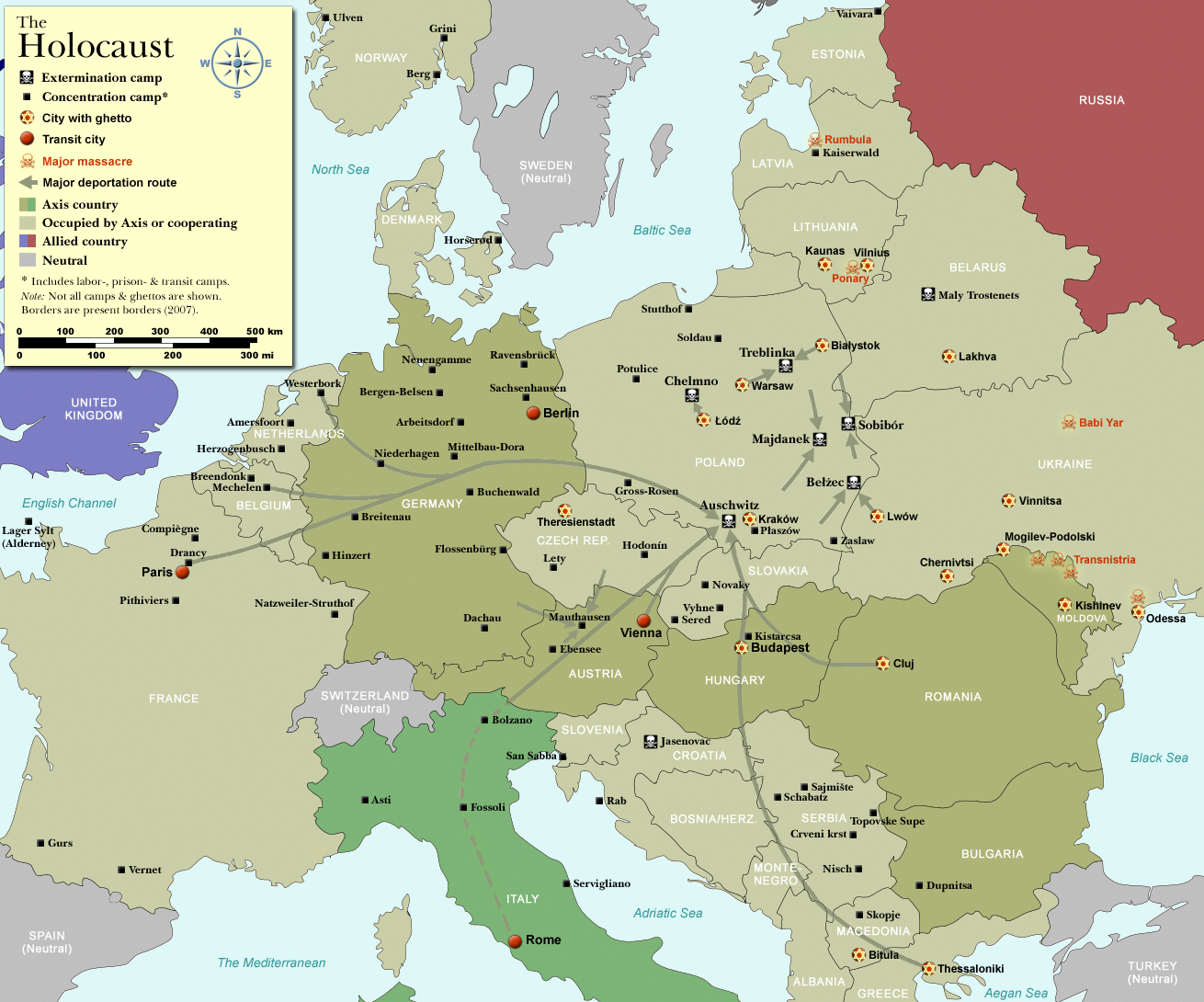
| Description |
Map of the Holocaust in Europe during World War II, 1939-1945. |
|---|---|
| Source |
Self-made by User:Dna-Dennis, using information from USHMM & Wikipedia. |
| Date |
December 17, 2007 |
| Author | |
| Permission (Reusing this image) |
CC, see below. The map is completely unrestricted for any Wikipedia/Wikimedia project. |
| Other versions | Image:WW2-Holocaust-Europe.png (1942 borders). If you have any opinions/suggestions, please contact me here on my talk page. |
 |
This map image should be recreated using vector graphics as an SVG file. This has several advantages; see Commons:Media for cleanup for more information. If an SVG form of this image is already available, please upload it. After uploading an SVG, replace this template with template {{Vector version available|new image name.svg}} in this image. |
|
العربية | Български | Català | Česky | Dansk | Deutsch | English | Esperanto | Español | Français | 한국어 | Italiano | Magyar | Lietuvių | Nederlands | 日本語 | Polski | Português | Română | Русский | Suomi | Svenska | Türkçe | Українська | Tiếng Việt | मराठी | 中文(繁體) | 中文(简体) | +/- |
|
[edit] Licensing
|
File history
Click on a date/time to view the file as it appeared at that time.
| Date/Time | Dimensions | User | Comment | |
|---|---|---|---|---|
| current | 10:40, 17 December 2007 | 1,310×1,090 (767 KB) | Dna-webmaster | (== Summary == {{Information |Description=Map of the Holocaust in Europe during World War II, 1939-1945. <br> This map shows all extermination camps (or ''death camps''), most major concentration camps, labor camps, prison camps, ghettos, major deportation) |

