Image:Wpdms nasa topo missoula floods.jpg
From Wikipedia, the free encyclopedia
No higher resolution available.
Wpdms_nasa_topo_missoula_floods.jpg (464 × 384 pixels, file size: 49 KB, MIME type: image/jpeg)
| | This is a file from the Wikimedia Commons. The description on its description page there is shown below.
|
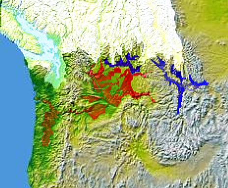
Glacial Lake Columbia (west) and Glacial Lake Missoula (east) are shown in blue, south of the Cordilleran Ice Sheet. The areas inundated during the Missoula Floods and Columbia Floods are shown in red.
© 2004 Matthew Trump.
http://en.wikipedia.org/wiki/Image:Wpdms_nasa_topo_missoula_floods.jpg

File history
Click on a date/time to view the file as it appeared at that time.
| Date/Time | Dimensions | User | Comment | |
|---|---|---|---|---|
| current | 18:59, 7 January 2006 | 464×384 (49 KB) | Mattes | (new) |
File links
The following pages on the English Wikipedia link to this file (pages on other projects are not listed):

