Image:WorldMapCosmasIndicopleustes.jpg
From Wikipedia, the free encyclopedia
Size of this preview: 764 × 600 pixels
Full resolution (1,539 × 1,208 pixels, file size: 654 KB, MIME type: image/jpeg)
| | This is a file from the Wikimedia Commons. The description on its description page there is shown below.
|
[edit] Summary
| Description |
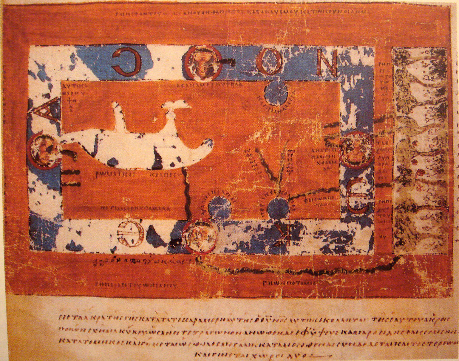
World Map by Cosmas Indicopleustes. The map is oriented with north to the top. It shows a rectangular landmass in the middle of the Okeanos (Cosmas believed that the world was flat and shaped like a tabernacle). The Mediterranean is shown in the western half, with indication of the Adriatic and the Aegaean+Euxine Seas to the north, the strait of Gibraltar to the west and the Nile to the south. Three further Seas are shown as connected to the Ocean, the Caspian to the northeast, and the Red Sea ("Arabian Gulf") and the Persian Gulf to the south, the latter joined by Euphrates and Tigris. Paradise is shown in the Far East, beyond the Ocean. |
|---|---|
| Source |
"Les Sciences au Moyen-Age", "Pour la Science" |
| Date |
6th century map. |
| Author |
Cosmas Indicopleustes, 6th century |
| Permission (Reusing this image) |
see below |
[edit] Licensing
This photographic reproduction is therefore also in the public domain. العربية | Česky | Deutsch | English | Ελληνικά | Español | فارسی | Français | עברית | Bahasa Indonesia | Italiano | 日本語 | 한국어 | Magyar | Nederlands | Polski | Português | Română | Русский | Slovenščina | Српски / Srpski | Basa Sunda | Türkçe | Українська | 中文(繁體) | 中文(简体) | +/- |
File history
Click on a date/time to view the file as it appeared at that time.
| Date/Time | Dimensions | User | Comment | |
|---|---|---|---|---|
| current | 18:33, 16 November 2007 | 1,539×1,208 (654 KB) | PHGCOM | ({{Information |Description=World Map by Cosmas Indicopleustes |Source="Les Sciences au Moyen-Age", "Pour la Science" |Date=6th century map. |Author=Cosmas Indicopleustes, 6th century |Permission= |other_versions= }} ) |
File links
Metadata
This file contains additional information, probably added from the digital camera or scanner used to create or digitize it. If the file has been modified from its original state, some details may not fully reflect the modified file.
| Camera manufacturer | SONY |
|---|---|
| Camera model | DSC-T10 |
| Exposure time | 1/8 sec (0.125) |
| F-number | f/3.5 |
| Date and time of data generation | 21:54, 15 November 2007 |
| Lens focal length | 6.33 mm |
| Orientation | Normal |
| Horizontal resolution | 72 dpi |
| Vertical resolution | 72 dpi |
| Software used | Paint Shop Pro Photo 11.20 |
| File change date and time | 19:30, 16 November 2007 |
| Y and C positioning | 2 |
| Exposure Program | Normal program |
| ISO speed rating | 320 |
| Exif version | 2.21 |
| Date and time of digitizing | 21:54, 15 November 2007 |
| Image compression mode | 8 |
| Exposure bias | 0 |
| Maximum land aperture | 3.625 |
| Metering mode | Pattern |
| Light source | Unknown |
| Flash | 16 |
| Color space | sRGB |
| Custom image processing | Normal process |
| Exposure mode | Auto exposure |
| White balance | Auto white balance |
| Scene capture type | Standard |
| Contrast | Normal |
| Saturation | Normal |
| Sharpness | Normal |

