Image:WorldCenterOfPopulation.png
From Wikipedia, the free encyclopedia
Size of this preview: 800 × 493 pixels
Full resolution (1,073 × 661 pixels, file size: 144 KB, MIME type: image/png)
| | This is a file from the Wikimedia Commons. The description on its description page there is shown below.
|
[edit] Summary
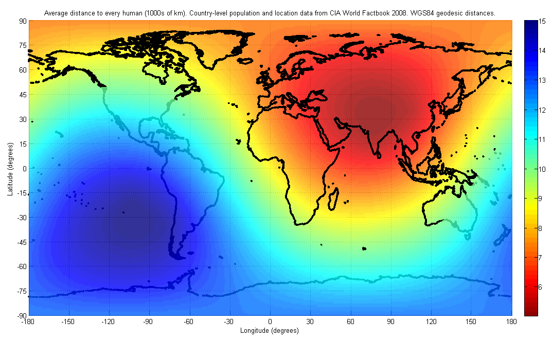
| Description |
English: The figure indicates the average distance to every human on earth, depending on location. The population and location data used are at the country-level, from the 2008 CIA World Factbook. The distance was computed first by finding the geodesic (shortest path) distance along the surface of the WGS84 reference ellipsoid to each country on the list, and then finding the weighted average of all such distances with the weight being the corresponding country's population. I have used only publicly available data for this image. The image may look slightly different in future, as world population distributions change. The image will also look different if a different distance metric is used, such as a Euclidean distance in three dimensions, which would allow for tunneling through the earth.
|
|---|---|
| Source |
Own work by uploader |
| Date |
20080602 |
| Author | |
| Permission (Reusing this image) |
see below |
[edit] Licensing:
|

File history
Click on a date/time to view the file as it appeared at that time.
| Date/Time | Dimensions | User | Comment | |
|---|---|---|---|---|
| current | 23:11, 2 June 2008 | 1,073×661 (144 KB) | Brhaspati | ({{Information |Description={{en|1=The figure indicates the average distance to every human on earth, depending on location. The population and location data used are at the country-level, from the 2008 CIA World Factbook. The distance was computed first b) |
File links
The following pages on the English Wikipedia link to this file (pages on other projects are not listed):

