Image:WalesWrexham.png
From Wikipedia, the free encyclopedia
No higher resolution available.
WalesWrexham.png (200 × 225 pixels, file size: 22 KB, MIME type: image/png)
| | This is a file from the Wikimedia Commons. The description on its description page there is shown below.
|
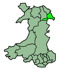
Wrexham in Wales
Русский: Карта_Рексхэм
Map by en:User:Morwen

File history
Click on a date/time to view the file as it appeared at that time.
| Date/Time | Dimensions | User | Comment | |
|---|---|---|---|---|
| current | 23:46, 26 June 2006 | 200×225 (22 KB) | Nichtbesserwisser | (Wrexham in Wales Map by en:User:Morwen Category:Maps of Wales {{GFDL}}) |
File links
The following pages on the English Wikipedia link to this file (pages on other projects are not listed):
- Wrexham (county borough)
- Rhosllannerchrugog
- Ruabon
- Rhosrobin
- Fenn's, Whixall and Bettisfield Mosses NNR
- Acrefair
- Clwydian Range
- Cadair Bronwen
- Abenbury
- River Clywedog
- River Alyn
- Marford
- Burton, Wrexham
- Template:Wrexham-geo-stub
- Pontfadog
- Rossett
- Brymbo
- Erbistock
- Maelor Way
- Hanmer
- Southsea, Wrexham
- River Cegidog
- Llanarmon Dyffryn Ceiriog
- Garden Village, Wrexham
- Johnstown, Wrexham
- Ceiriog Ucha
- Bryn Offa
- History of Wrexham
- Rhostyllen
- Wynnstay
- Horseman's Green
- Bronington
- Marchwiel
- Willington Worthenbury
- Arowry

