Image:W Sahara Map.png
From Wikipedia, the free encyclopedia
No higher resolution available.
W_Sahara_Map.png (685 × 528 pixels, file size: 18 KB, MIME type: image/png)
| | This is a file from the Wikimedia Commons. The description on its description page there is shown below.
|
| Description |
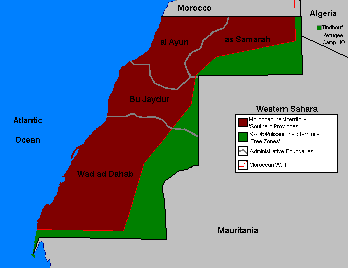
SummaryMap of Western Sahara for use on Wikipedia. |
|---|---|
| Source | No source specified. Please edit this image description and provide a source. |
| Date | |
| Author |
User Orthuberra on en.wikipedia |
| Permission (Reusing this image) |
|
| Other versions |
Originally from en.wikipedia; description page is (was) here * 21:51, 29 September 2006 [[:en:User:Orthuberra|Orthuberra]] 685×528 (18,177 bytes) <span class="comment">(Map of Western Sahara for use on Wikipedia.)</span> |

(Uploaded using CommonsHelper or PushForCommons)
File history
Click on a date/time to view the file as it appeared at that time.
| Date/Time | Dimensions | User | Comment | |
|---|---|---|---|---|
| current | 09:26, 2 October 2006 | 685×528 (18 KB) | Sven-steffen arndt | ({{Information| |Description= == Summary == Map of Western Sahara for use on Wikipedia. |Source= |Date= |Author=User Orthuberra on [http://en.wikipedia.org en.wikipedia] |Permission={{GFDL-user-w|en|wikipedia|Orthuberra}} |other_ver) |
File links
The following pages on the English Wikipedia link to this file (pages on other projects are not listed):

