Image:US FRONTIER STRIP.PNG
From Wikipedia, the free encyclopedia
No higher resolution available.
US_FRONTIER_STRIP.PNG (572 × 371 pixels, file size: 15 KB, MIME type: image/png)
| | This is a file from the Wikimedia Commons. The description on its description page there is shown below.
|
[edit] Summary
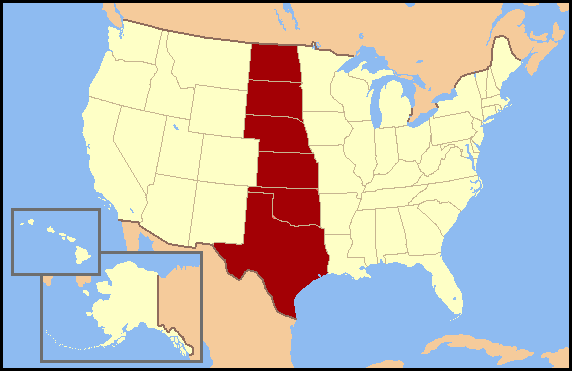
Frontier Strip refers to the six U.S. states from North Dakota south to Texas. These states form a nearly straight line from north to south and roughly correspond to the Great Plains region of the United States. The term Frontier Strip is probably correlated to the 1880 census, where these six states, some of which were territories at the time, were part of the "Frontier Line," the geographic designation by the U.S. Census Bureau that proclaimed where the civilitation of the Eastern United States ended and the historic American Wild West began. In the 1890 census, it stated, "Up to and including 1880 the country had a frontier of settlement, but at present the unsettled area has been so broken into by isolated bodies of settlement that there can hardly be said to be a frontier line. In the discussion of its extent, its westward movement, etc., it can not, therefore, any longer have a place in the census reports."
[edit] Licensing

File history
Click on a date/time to view the file as it appeared at that time.
| Date/Time | Dimensions | User | Comment | |
|---|---|---|---|---|
| current | 15:43, 3 July 2007 | 572×371 (15 KB) | Jannizz | (== Summary == Frontier Strip refers to the six U.S. states from North Dakota south to Texas. These states form a nearly straight line from north to south and roughly correspond to the Great Plains region of the United States. The term Frontier Strip i) |

