Image:United States 2004 election maps.png
From Wikipedia, the free encyclopedia
No higher resolution available.
United_States_2004_election_maps.png (717 × 449 pixels, file size: 131 KB, MIME type: image/png)
| | This is a file from the Wikimedia Commons. The description on its description page there is shown below.
|
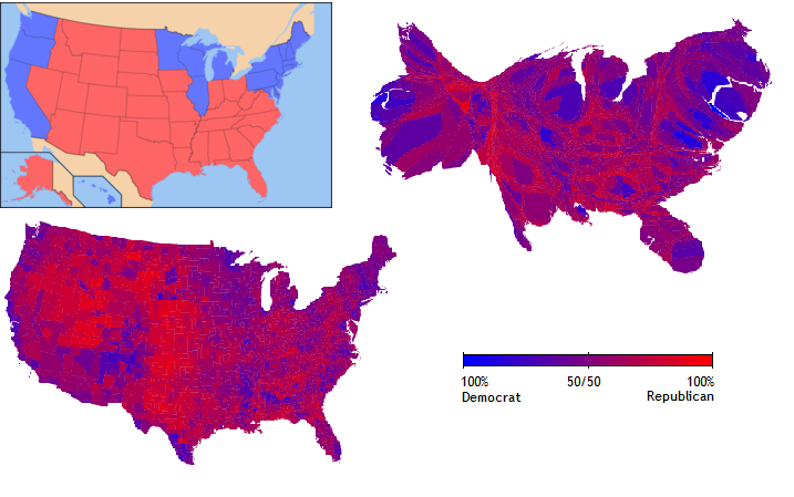
A composite of three Wikipedia images: Image:United States Elections 2004 Electoral College map.png, w:Image:2004 US elections purple counties.png, and w:Image:Cartlinearlarge.png.
The top left image is a simple red/blue map of the 2004 U.S. Presidential Election, shown by statewide electoral votes. At bottom left is a red/blue map of the election, shown by counties. At top right is a cartogram, where the results from the bottom left map have been resized according to population.
The images this image is composed from are {{cc-by-2.0}}, except the upper-left map, which is {{GFDL}}. The whole point of cc-by is that modified versions don't have to have the same license.

Attribution: The lower-left and upper-right maps are due to Michael Gastner, Cosma Shalizi, and Mark Newman of the University of Michigan, with slight modifications by Jaap Vermeulen and Ed Sanders, while the upper-left is due to Ed Sanders and Eric Pierce. The image was composed and originally uploaded to the English Wikipedia by w:User:Deltabeignet.
File history
Click on a date/time to view the file as it appeared at that time.
| Date/Time | Dimensions | User | Comment | |
|---|---|---|---|---|
| current | 01:59, 24 May 2005 | 717×449 (131 KB) | Zscout370 | (A composite of three Wikipedia images: Image:2004 US elections map.png Image:2004 US elections purple counties.png Image:Cartlinearlarge.png The top left image is a simple red/blue map of the 2004 U.S. Presidential Election, shown by statewide electoral ) |

