Image:Tropical Storm Hanna (2002).jpg
From Wikipedia, the free encyclopedia
No higher resolution available.
Tropical_Storm_Hanna_(2002).jpg (642 × 482 pixels, file size: 53 KB, MIME type: image/jpeg)
| | This is a file from the Wikimedia Commons. The description on its description page there is shown below.
|
[edit] Summary
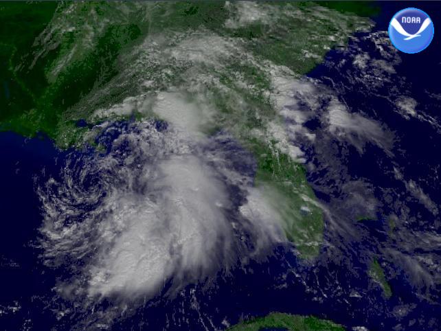
| Description |
The National Weather Service's Tropical Prediction Center shows Tropical Storm Hanna 105 miles south-southwest of the mouth of the Mississippi River. Winds are sustained at 45 MPH with stronger gusts. |
|||
|---|---|---|---|---|
| Source |
http://www.nnvl.noaa.gov/cgi-bin/index.cgi?page=items&ser=104823 |
|||
| Date |
2002-09-13 |
|||
| Author |
NOAA / Satellite and Information Service |
|||
| Permission (Reusing this image) |
|
File history
Click on a date/time to view the file as it appeared at that time.
| Date/Time | Dimensions | User | Comment | |
|---|---|---|---|---|
| current | 18:28, 12 November 2006 | 642×482 (53 KB) | Good kitty | |
| 13:58, 25 December 2005 | 320×240 (15 KB) | Hurricanehink | (From http://www.nnvl.noaa.gov/cgi-bin/index.cgi?page=items&ser=104823, this image shows Tropical Storm Hanna in the Gulf of Mexico on September 13, 2002. Despite its disorganized nature, Hanna has winds of 45 mph as it moves to the northwest. {{PD-USGov-) |
File links
The following pages on the English Wikipedia link to this file (pages on other projects are not listed):


.jpg)