Image:Tropical Storm Debby TRMM Image (2006).jpg
From Wikipedia, the free encyclopedia
Size of this preview: 600 × 600 pixels
Full resolution (1,024 × 1,024 pixels, file size: 215 KB, MIME type: image/jpeg)
| | This is a file from the Wikimedia Commons. The description on its description page there is shown below.
|
[edit] Summary
| Description |
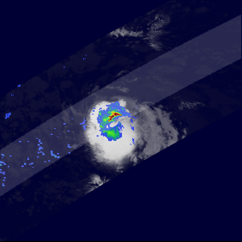
Compared to last year’s onslaught, the 2006 Atlantic hurricane season has so far been relatively uneventful, with no storm having reached hurricane strength as of mid-August. However, late August is when the Atlantic hurricane season becomes most active. As of August 24, 2006, Tropical Storm Debby was making its way through the central Atlantic and posed no immediate threat to any land areas. Known as a Cape Verde storm because of its formation in the far eastern Atlantic near the Cape Verde Islands, Debby began as a tropical depression on August 21, 2006, from an African easterly wave that moved off the coast of west Africa. This image was taken by the Tropical Rainfall Measuring Mission (TRMM) satellite on August 24, 2006, at 02:07 a.m. UTC (August 23 at 10:07 p.m. EDT) as Debby was moving northwest through the central Atlantic. TRMM reveals that Debby was a small, compact storm; however, a band of intense rain (dark red area) is apparent north of the center and indicates an area of active convection (uprising air). The TRMM satellite was placed into service in November 1997. From its low-earth orbit, TRMM provides valuable images and information on storm systems around the tropics using a combination of passive microwave and active radar sensors, including the first precipitation radar in space. TRMM is a joint mission between NASA and the Japanese Aerospace Exploration Agency. |
|||||
|---|---|---|---|---|---|---|
| Source |
http://earthobservatory.nasa.gov/NaturalHazards/Archive/Aug2006/debby_trmm_2006236_lrg.jpg |
|||||
| Date | ||||||
| Author |
NASA satellite image created by the Earth Observatory, using data obtained courtesy of the Tropical Rainfall Measuring Mission (TRMM). |
|||||
| Permission (Reusing this image) |
|

File history
Click on a date/time to view the file as it appeared at that time.
| Date/Time | Dimensions | User | Comment | |
|---|---|---|---|---|
| current | 07:29, 4 November 2006 | 1,024×1,024 (215 KB) | Alastor Moody | (Compared to last year’s onslaught, the 2006 Atlantic hurricane season has so far been relatively uneventful, with no storm having reached hurricane strength as of mid-August. However, late August is when the Atlantic hurricane season becomes most active) |
File links
Metadata
This file contains additional information, probably added from the digital camera or scanner used to create or digitize it. If the file has been modified from its original state, some details may not fully reflect the modified file.
| Width | 1024 |
|---|---|
| Height | 1024 |
| Compression scheme | Uncompressed |
| Pixel composition | RGB |
| Orientation | Normal |
| Number of components | 3 |
| Horizontal resolution | 72 dpi |
| Vertical resolution | 72 dpi |
| Data arrangement | chunky format |
| Software used | Adobe Photoshop CS2 Macintosh |
| File change date and time | 15:59, 24 August 2006 |
| Color space | 65535 |

