Image:Sp-map.png
From Wikipedia, the free encyclopedia
No higher resolution available.
Sp-map.png (328 × 353 pixels, file size: 18 KB, MIME type: image/png)
| | This is a file from the Wikimedia Commons. The description on its description page there is shown below.
|
| Description |
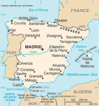
CIA map of Spain. |
|---|---|
| Source |
CIA |
| Date |
4 March 2005 |
| Author | |
| Permission (Reusing this image) |
see below |
| Other versions | Image:Sp-map (zh).png |
| This image is in the public domain because it contains materials that originally came from the United States Central Intelligence Agency's World Factbook.
Deutsch | English | Español | Français | 日本語 | Nederlands | 한국어 | Português | தமிழ் | Magyar | +/- |
 |
File history
Click on a date/time to view the file as it appeared at that time.
| Date/Time | Dimensions | User | Comment | |
|---|---|---|---|---|
| current | 18:14, 23 December 2005 | 328×353 (18 KB) | Dbenbenn | (Reverted to earlier revision) |
| 22:53, 30 November 2005 | 351×377 (27 KB) | Porao | (Fuente original: CIA World Factbook. Mapa de España en español/castellano. Traducido por es:Usuario:Wesisnay. {{PD-USGov-CIA-WF}} Category:Maps of Spain) | |
| 23:06, 4 March 2005 | 328×353 (18 KB) | Alfio | (CIA map of Spain) |
File links
The following pages on the English Wikipedia link to this file (pages on other projects are not listed):

