Image:Siouxreservationmap.png
From Wikipedia, the free encyclopedia
No higher resolution available.
Siouxreservationmap.png (500 × 500 pixels, file size: 259 KB, MIME type: image/png)
| | This is a file from the Wikimedia Commons. The description on its description page there is shown below.
|
| Description |
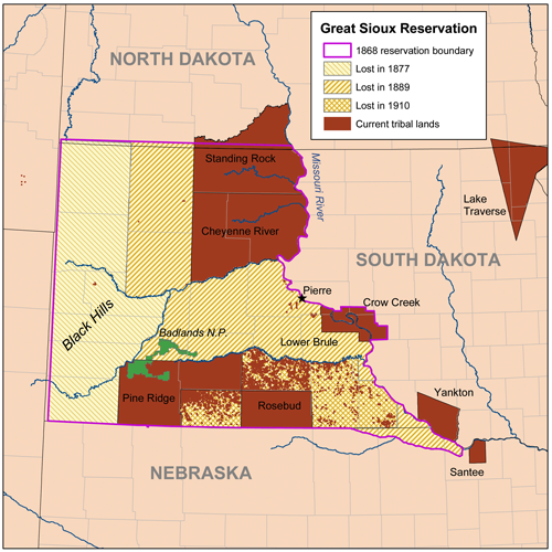
Map of the Great Sioux Reservation. |
|---|---|
| Source |
self-made, using National Atlas data and original treaty descriptions. |
| Date |
March 18, 2008 |
| Author | |
| Permission (Reusing this image) |
see below |
|
File history
Click on a date/time to view the file as it appeared at that time.
| Date/Time | Dimensions | User | Comment | |
|---|---|---|---|---|
| current | 14:50, 19 March 2008 | 500×500 (259 KB) | Kmusser | (Corrected southern border.) |
| 19:08, 18 March 2008 | 500×500 (257 KB) | Kmusser | ({{Information |Description=Map of the Great Sioux Reservation. |Source=self-made, using National Atlas data and original treaty descriptions. |Date=March 18, 2008 |Author= [[User:) |
File links
The following pages on the English Wikipedia link to this file (pages on other projects are not listed):

