Image:SiberiaMap.png
From Wikipedia, the free encyclopedia
No higher resolution available.
SiberiaMap.png (300 × 178 pixels, file size: 22 KB, MIME type: image/png)
| | This is a file from the Wikimedia Commons. The description on its description page there is shown below.
|
[edit] Summary
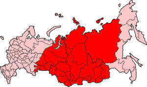
| Description |
English: Map of Russia with West Siberian Plain and the Central Siberian Plateau highlighted. Uploaded on 29 December 2004, 08:56, by user Foobaz on English Wikipedia with description "Map of Siberia made from Image:RussiaSakha.png" and released under GFDL v1.2 license.
|
|---|---|
| Source |
Transfered from en.wikipedia |
| Date |
2004-12-29 (original upload date) |
| Author |
Original uploader was Foobaz at en.wikipedia |
| Permission (Reusing this image) |
GFDL-WITH-DISCLAIMERS; Released under the GNU Free Documentation License. |
[edit] Licensing
 |
Permission is granted to copy, distribute and/or modify this document under the terms of the GNU Free Documentation License, Version 1.2 or any later version published by the Free Software Foundation; with no Invariant Sections, no Front-Cover Texts, and no Back-Cover Texts. Subject to disclaimers. Asturianu | Български | Català | Deutsch | English | Español | Français | Gaeilge | Italiano | 한국어 | 日本語 | Polski | Português | Română | Türkçe | +/- |
[edit] Original upload log
The original description page is/was here. All following user names refer to en.wikipedia.
- 2004-12-29 08:56 Foobaz 300×178×8 (22240 bytes) Map of [[Siberia]] made from [[:Image:RussiaSakha.png]]. {{GFDL}}
File history
Click on a date/time to view the file as it appeared at that time.
| Date/Time | Dimensions | User | Comment | |
|---|---|---|---|---|
| current | 19:14, 12 November 2005 | 300×178 (22 KB) | Bggoldie | (Map of Russia with West Siberian Plain and the Central Siberian Plateau highlighted. Uploaded on 29 December 2004, 08:56, by user Foobaz on English Wikipedia with description "Map of Siberia made from :Image:RussiaSakha.png" and released under GFDL v1.2 l) |
File links
The following pages on the English Wikipedia link to this file (pages on other projects are not listed):

