Image:Scattometer principle.GIF
From Wikipedia, the free encyclopedia
No higher resolution available.
Scattometer_principle.GIF (406 × 370 pixels, file size: 15 KB, MIME type: image/gif)
| | This is a file from the Wikimedia Commons. The description on its description page there is shown below.
|
| Description |
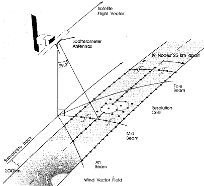
Scatterometer instruments on board satellites |
|||
|---|---|---|---|---|
| Source |
provide an estimation of the surface wind vector with high spatial and temporal resolution over all ocean basins. |
|||
| Date |
2007-03-07 |
|||
| Author | ||||
| Permission (Reusing this image) |
|
|||
| Other versions | Image:Principe_diffusometre_satellite.png in French |
File history
Click on a date/time to view the file as it appeared at that time.
| Date/Time | Dimensions | User | Comment | |
|---|---|---|---|---|
| current | 20:15, 7 March 2007 | 406×370 (15 KB) | Pierre cb | ({{Information |Description=Scatterometer instruments on board satellites |Source=provide an estimation of the surface wind vector with high spatial and temporal resolution over all ocean basins. |Date=2007-03-07 |Author= [[http://www.nodc.noaa.gov/woce_V) |
File links
The following pages on the English Wikipedia link to this file (pages on other projects are not listed):

