Image:Santa Monica Bay Map.jpg
From Wikipedia, the free encyclopedia
No higher resolution available.
Santa_Monica_Bay_Map.jpg (468 × 597 pixels, file size: 283 KB, MIME type: image/jpeg)
| | This is a file from the Wikimedia Commons. The description on its description page there is shown below.
|
[edit] Summary
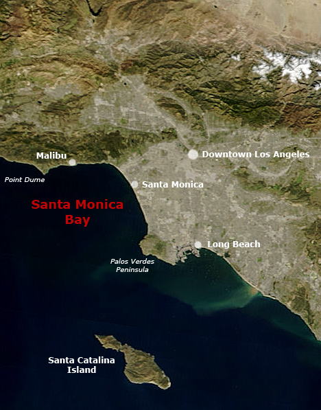
following the original text out of the english wikipedia, where it was originally uploaded: Map of Southern California with Santa Monica Bay identified
Underlying map is an aerial map obtained from NASA (original:
http://earthobservatory.nasa.gov/NaturalHazards/Archive/Nov2004/California_TMO_2004304_lrg.jpeg
The labeling is by en:User:Mikeetc
[edit] Licensing
| This work is in the public domain in the United States because it is a work of the United States Federal Government under the terms of Title 17, Chapter 1, Section 105 of the US Code. See Copyright.
Note: This only applies to works of the Federal Government and not to the work of any individual U.S. state, territory, commonwealth, county, municipality, or any other subdivision. العربية | Български | Česky | Deutsch | English | Español | Français | Magyar | Italiano | 日本語 | 한국어 | Polski | Português | 中文(繁體) | 中文(简体) | +/- |
 |
File history
Click on a date/time to view the file as it appeared at that time.
| Date/Time | Dimensions | User | Comment | |
|---|---|---|---|---|
| current | 23:55, 28 May 2006 | 468×597 (283 KB) | Otto Normalverbraucher | (following the original text out of the english wikipedia, where it was originally uploaded: ''Map of Southern California with Santa Monica Bay identified Underlying map is an aerial map obtained from NASA (original: http://earthobservatory.nasa.gov/Natu) |
File links
Metadata
This file contains additional information, probably added from the digital camera or scanner used to create or digitize it. If the file has been modified from its original state, some details may not fully reflect the modified file.
| Orientation | Normal |
|---|---|
| Horizontal resolution | 72 dpi |
| Vertical resolution | 72 dpi |
| Software used | Adobe Photoshop CS2 Windows |
| File change date and time | 14:52, 16 December 2005 |
| Color space | 65535 |

