Image:RiftValleyLakes.JPG
From Wikipedia, the free encyclopedia
No higher resolution available.
RiftValleyLakes.JPG (600 × 392 pixels, file size: 46 KB, MIME type: image/jpeg)
| | This is a file from the Wikimedia Commons. The description on its description page there is shown below.
|
| Description |
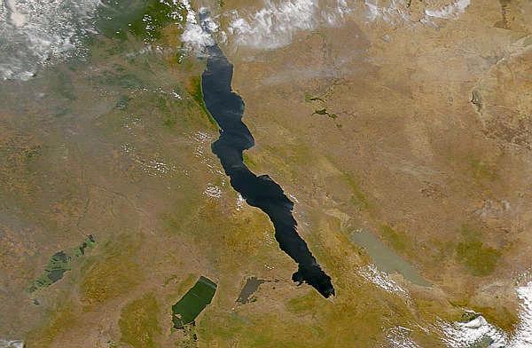
The lakes of the African Rift Valley exhibit wide variations in water color as can be seen in this SeaWiFS image. From left to right the lakes are: Lake Upembe, Lake Mwaru, Lake Tanganyika (largest), and Lake Rukwa. This image spans the southeastern corner of the Democratic Republic of the Congo, northeastern Zambia, and southern Tanzania. |
|---|---|
| Source |
http://visibleearth.nasa.gov/view_rec.php?id=757
|
| Date |
2000-07-23 |
| Author |
SeaWiFS Project, NASA/Goddard Space Flight Center, and ORBIMAGE |
| Permission (Reusing this image) |
see below |
[edit] Licensing
| This image is from the Sea-viewing Wide Field-of-view Sensor (SeaWiFS) Project. Satellite data captured by the SeaWIFS sensor are released into the public domain 5 years after capture.[1] Data less than five years old can be re-used only for educational or scientific purposes; any commercial use of such images must be coordinated with ORBIMAGE/GeoEye. |
File history
Click on a date/time to view the file as it appeared at that time.
| Date/Time | Dimensions | User | Comment | |
|---|---|---|---|---|
| current | 08:58, 10 April 2006 | 600×392 (46 KB) | Matt Crypto | (==Summary== '''Source:''' NASA image from http://visibleearth.nasa.gov/cgi-bin/viewrecord?2559 ==Licensing== {{PD-USGov-NASA}} ==See also== * en:Image:RiftValleyLakes.JPG) |
File links
The following pages on the English Wikipedia link to this file (pages on other projects are not listed):

