Image:Quiberon on nasa map.jpg
From Wikipedia, the free encyclopedia
No higher resolution available.
Quiberon_on_nasa_map.jpg (267 × 314 pixels, file size: 22 KB, MIME type: image/jpeg)
| | This is a file from the Wikimedia Commons. The description on its description page there is shown below.
|
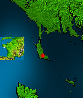
White point on mini map marks, which part of France is shown. Red point marks the city w:Quiberon on the peninsula of Quiberon. In the east of the peninsula there is the bay of Quiberon. In the south you see a part of w:Belle Île.
- This map is based on a NASA work, which is considered to be public domain (see box below), source: http://photojournal.jpl.nasa.gov/catalog/PIA03393
- Edits by Matthäus Wander are licensed unter GFDL, see box

| This image uses high-resolution digital topography data from NASA's Shuttle Radar Topography Mission (SRTM) at JPL-Caltech. It is in the public domain |
|
File history
Click on a date/time to view the file as it appeared at that time.
| Date/Time | Dimensions | User | Comment | |
|---|---|---|---|---|
| current | 19:21, 18 April 2005 | 267×314 (22 KB) | Matthäus Wander | (White point on mini map marks, which part of France is shown. Red point marks the city w:Quiberon on the peninsula of Quiberon. In the east of the peninsula there is the bay of Quiberon. In the south you see a part of w:Belle Île. * This map) |
File links
The following pages on the English Wikipedia link to this file (pages on other projects are not listed):

