Image:PrairiePotholeRegionMap.gif
From Wikipedia, the free encyclopedia
No higher resolution available.
PrairiePotholeRegionMap.gif (295 × 302 pixels, file size: 5 KB, MIME type: image/gif)
| | This is a file from the Wikimedia Commons. The description on its description page there is shown below.
|
| Description |
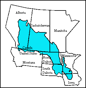
English: Map of the Prairie Pothole Region of North America. From the US Geological Survey, http://www.npwrc.usgs.gov/resource/wetlands/pothole/prairie.htm
|
|---|---|
| Source |
Transferred from en.wikipedia; Transfer was stated to be made by User:Orlady. |
| Date |
2007-10-15 (original upload date) |
| Author |
Original uploader was Orlady at en.wikipedia |
| Permission (Reusing this image) |
PD-USGOV. |
[edit] License information
| This work is in the public domain in the United States because it is a work of the United States Federal Government under the terms of Title 17, Chapter 1, Section 105 of the US Code. See Copyright.
Note: This only applies to works of the Federal Government and not to the work of any individual U.S. state, territory, commonwealth, county, municipality, or any other subdivision. العربية | Български | Česky | Deutsch | English | Español | Français | Magyar | Italiano | 日本語 | 한국어 | Polski | Português | 中文(繁體) | 中文(简体) | +/- |
 |
[edit] Original upload log
The original description page is/was here. All following user names refer to en.wikipedia.
- 2007-10-15 17:21 Orlady 295×302×8 (4921 bytes) Map of the Prairie Pothole Region of North America. From the US Geological Survey, http://www.npwrc.usgs.gov/resource/wetlands/pothole/prairie.htm
File history
Click on a date/time to view the file as it appeared at that time.
| Date/Time | Dimensions | User | Comment | |
|---|---|---|---|---|
| current | 01:53, 6 April 2008 | 295×302 (5 KB) | File Upload Bot (Magnus Manske) | ( {{BotMoveToCommons|en.wikipedia}} {{Information |Description={{en|Map of the Prairie Pothole Region of North America. From the US Geological Survey, http://www.npwrc.usgs.gov/resource/wetlands/pothole/prairie.htm}} |Source=Transferred from [http://en.wik) |
File links
The following pages on the English Wikipedia link to this file (pages on other projects are not listed):

