Image:Polska 960 - 992.png
From Wikipedia, the free encyclopedia
Size of this preview: 607 × 599 pixels
Full resolution (2,309 × 2,279 pixels, file size: 1.17 MB, MIME type: image/png)
| | This is a file from the Wikimedia Commons. The description on its description page there is shown below.
|
| Description |
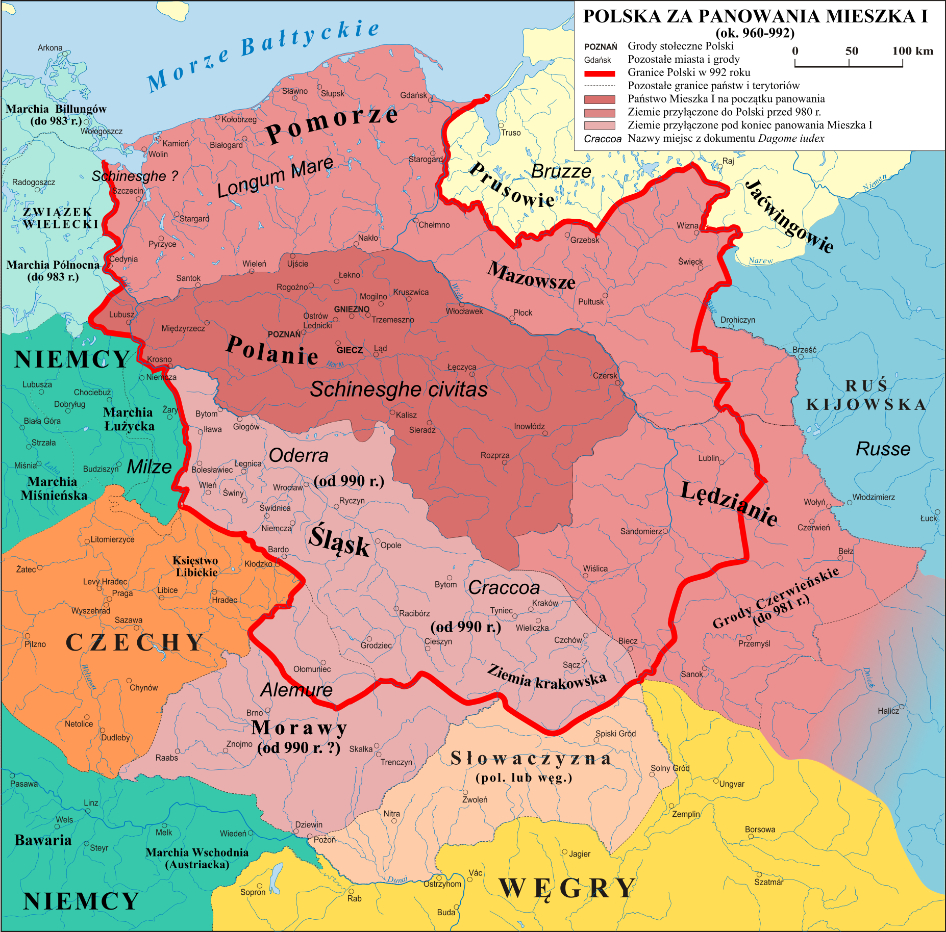
Mapa Polski za panowania Mieszka I (ok. 960 - 992) |
|---|---|
| Source |
własna praca na podstawie: "Ilustrowany Atlas Historii Polski" i publikacji o badaniach na Ostrwie Tumskim w Poznaniu. |
| Date |
2.01.2007 |
| Author | |
| Permission (Reusing this image) |
|

File history
Click on a date/time to view the file as it appeared at that time.
| Date/Time | Dimensions | User | Comment | |
|---|---|---|---|---|
| current | 14:12, 21 May 2008 | 2,309×2,279 (1.17 MB) | Poznaniak | (Reverted to version as of 15:23, 6 February 2008) |
| 13:25, 21 May 2008 | 2,309×2,279 (1.2 MB) | Fz22 | (Reverted to version as of 13:43, 20 May 2008) | |
| 15:40, 20 May 2008 | 2,309×2,279 (1.17 MB) | Poznaniak | (Reverted to version as of 15:23, 6 February 2008) | |
| 13:43, 20 May 2008 | 2,309×2,279 (1.2 MB) | Fz22 | (Reverted to version as of 14:18, 19 May 2008) | |
| 16:30, 19 May 2008 | 2,309×2,279 (1.17 MB) | Poznaniak | (Reverted to version as of 15:23, 6 February 2008) | |
| 14:18, 19 May 2008 | 2,309×2,279 (1.2 MB) | Fz22 | (Reverted to version as of 19:52, 15 May 2008) | |
| 16:39, 17 May 2008 | 2,309×2,279 (1.17 MB) | Poznaniak | (Reverted to version as of 15:23, 6 February 2008) | |
| 19:52, 15 May 2008 | 2,309×2,279 (1.2 MB) | Fz22 | (Reverted to version as of 09:19, 14 May 2008) | |
| 17:02, 14 May 2008 | 2,309×2,279 (1.17 MB) | Poznaniak | (Reverted to version as of 15:23, 6 February 2008) | |
| 09:19, 14 May 2008 | 2,309×2,279 (1.2 MB) | Fz22 | (- new border of "Morawy" - Slovakia deleted from a mid 900s map ... - 'Res nullis' lands added between the Magyars and their neighbours) | |
| 15:23, 6 February 2008 | 2,309×2,279 (1.17 MB) | Poznaniak | ({{Information |Description= |Source= |Date= |Author= |Permission= |other_versions= }} ) | |
| 18:42, 16 January 2008 | 2,309×2,279 (1.1 MB) | Poznaniak | ({{Information |Description= |Source= |Date= |Author= |Permission= |other_versions= }} ) | |
| 15:09, 2 December 2007 | 2,309×2,279 (1.1 MB) | Poznaniak | ||
| 15:03, 2 December 2007 | 2,310×2,280 (1.13 MB) | Poznaniak | ||
| 14:59, 2 December 2007 | 2,309×2,279 (596 KB) | Poznaniak | ||
| 14:13, 6 October 2007 | 2,309×2,279 (1.09 MB) | Poznaniak | ||
| 17:41, 22 June 2007 | 2,309×2,279 (1.12 MB) | Poznaniak | ||
| 17:33, 20 June 2007 | 2,309×2,279 (1.12 MB) | Poznaniak | ||
| 17:13, 27 April 2007 | 2,310×2,280 (1.13 MB) | Poznaniak | ||
| 17:38, 17 April 2007 | 2,310×2,280 (1.14 MB) | Poznaniak | ||
| 12:55, 13 April 2007 | 2,310×2,280 (1.14 MB) | Poznaniak | ||
| 14:38, 5 April 2007 | 2,310×2,280 (1.15 MB) | Poznaniak | ||
| 10:43, 27 March 2007 | 2,310×2,280 (1.15 MB) | Poznaniak | ||
| 18:38, 14 February 2007 | 2,310×2,280 (1.15 MB) | Poznaniak | ||
| 15:46, 3 January 2007 | 2,310×2,280 (1.14 MB) | Poznaniak | ||
| 18:25, 2 January 2007 | 2,310×2,280 (1.13 MB) | Poznaniak | ({{Information |Description=Mapa Polski za panowania Mieszka I (ok. 960 - 992) |Source=własna praca |Date=2.01.2007 |Author=Poznaniak |Permission={{self2|GFDL|cc-by-sa-2.5,2.0,1.0}} }} Category:Maps of the history of Poland ) |
File links
The following pages on the English Wikipedia link to this file (pages on other projects are not listed):

