Image:Polandmap cia gdansk.png
From Wikipedia, the free encyclopedia
No higher resolution available.
Polandmap_cia_gdansk.png (246 × 400 pixels, file size: 20 KB, MIME type: image/png)
| | This is a file from the Wikimedia Commons. The description on its description page there is shown below.
|
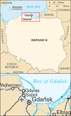
Map of Poland showing relative position of Gdansk, Gdynia and Sopot.
* Mapping from CIA World Factbook and United Nations map of Poland - see http://www.un.org/Depts/Cartographic/map/profile/poland.pdf
* Composited by ChrisO, Feb 18, 2004
CIA World Factbook
This image is a map or flag taken and/or modified from the Central Intelligence Agency's World Factbook. Under United States copyright law, all information and images from the World Factbook are in the public domain.
| This image is in the public domain because it contains materials that originally came from the United States Central Intelligence Agency's World Factbook.
Deutsch | English | Español | Français | 日本語 | Nederlands | 한국어 | Português | தமிழ் | Magyar | +/- |
 |
File history
Click on a date/time to view the file as it appeared at that time.
| Date/Time | Dimensions | User | Comment | |
|---|---|---|---|---|
| current | 17:13, 9 July 2005 | 246×400 (20 KB) | Michiel1972 | (Map of Poland showing relative position of Gdansk, Gdynia and Sopot. * Mapping from CIA World Factbook and United Nations map of Poland - see http://www.un.org/Depts/Cartographic/map/profile/poland.pdf * Composited by ChrisO, Feb 18, 2004 CIA W) |
File links
The following pages on the English Wikipedia link to this file (pages on other projects are not listed):

