Image:PNW-straits.jpg
From Wikipedia, the free encyclopedia
No higher resolution available.
PNW-straits.jpg (336 × 396 pixels, file size: 128 KB, MIME type: image/jpeg)
| | This is a file from the Wikimedia Commons. The description on its description page there is shown below.
|
[edit] Summary
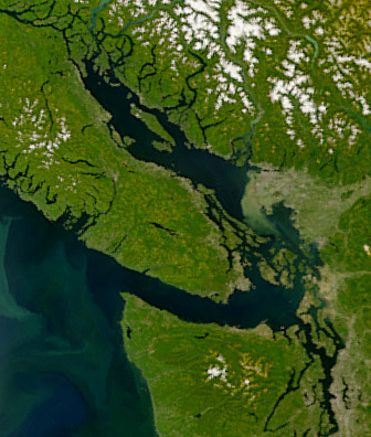
| Description |
Satellite image of the Strait of Georgia, Strait of Juan de Fuca, and surrounding region. The image was acquired by the Sea-viewing Wide Field-of-view Sensor (SeaWiFS) on August 9, 2001. Original image cropped to highlight the Strait of Georgia. |
|---|---|
| Source |
NASAEarth Observatory, http://earthobservatory.nasa.gov/Newsroom/NewImages/images.php3?img_id=5051 |
| Date |
April 21, 2008 |
| Author |
NASA |
| Permission (Reusing this image) |
see below |
[edit] Licensing
|
|
This file is in the public domain because it was created by NASA. NASA copyright policy states that "NASA material is not protected by copyright unless noted". (NASA copyright policy page or JPL Image Use Policy).
Deutsch | English | Español | Français | Nederlands | Português | Русский | 中文(简体) | 中文(繁體) | +/- |
|
 |
Warnings:
|
File history
Click on a date/time to view the file as it appeared at that time.
| Date/Time | Dimensions | User | Comment | |
|---|---|---|---|---|
| current | 06:55, 22 April 2008 | 336×396 (128 KB) | Pfly | ({{Information |Description=Satellite image of the Strait of Georgia, Strait of Juan de Fuca, and surrounding region. The image was acquired by the Sea-viewing Wide Field-of-view Sensor (SeaWiFS) on ) |
File links
Metadata
This file contains additional information, probably added from the digital camera or scanner used to create or digitize it. If the file has been modified from its original state, some details may not fully reflect the modified file.
| Orientation | Normal |
|---|---|
| Horizontal resolution | 72 dpi |
| Vertical resolution | 72 dpi |
| Software used | Adobe Photoshop CS2 Macintosh |
| File change date and time | 23:42, 21 April 2008 |
| Color space | sRGB |

