Image:Plymouthcolonymap.png
From Wikipedia, the free encyclopedia
Size of this preview: 741 × 600 pixels
Full resolution (1,235 × 1,000 pixels, file size: 439 KB, MIME type: image/png)
| | This is a file from the Wikimedia Commons. The description on its description page there is shown below.
|
| Description |
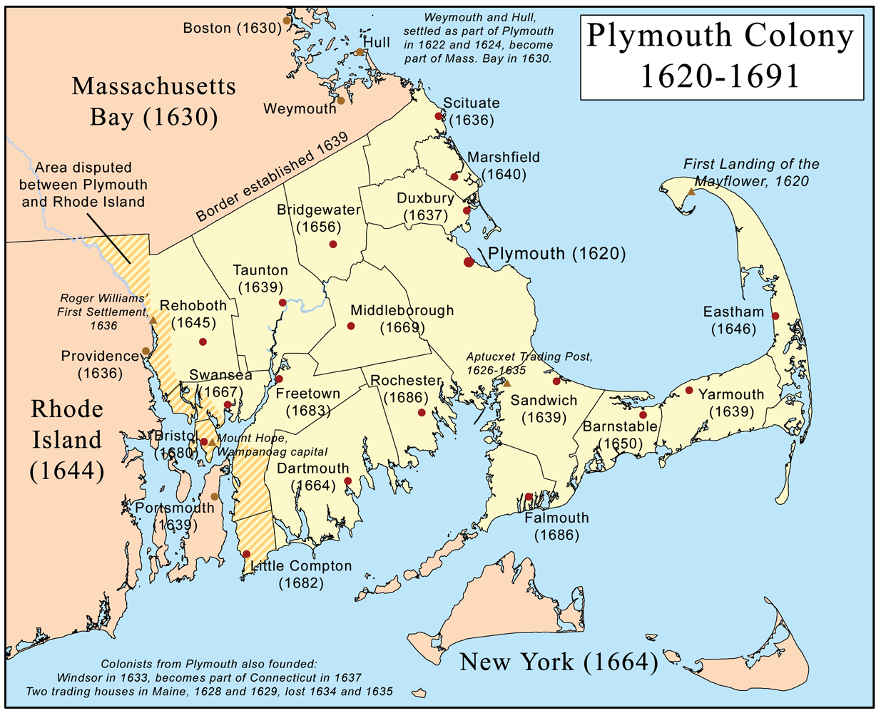
This is a map of Plymouth Colony that I made. |
|---|---|
| Source |
self-made. Websites consulted: The Border is Where? Part II The Survey System of the Old Colony Timeline of Plymouth Colony Rootsweb - Plymouth County towns Rootsweb - Barnstable County CapeCodHistory.us Rootsweb - Bristrol County towns Rootsweb - Rhode Island counties Rochester (MA) Town History Barrington, RI history Little Compton Historical Society The History of Cumberland RIEDC - Town of Bristol History of Weymouth Massachusetts City and Town Incorporation and Settlement Dates |
| Date |
June 12, 2007 |
| Author | |
| Permission (Reusing this image) |
see below |
[edit] Licensing
|
[edit] Format
 |
This map image should be recreated using vector graphics as an SVG file. This has several advantages; see Commons:Media for cleanup for more information. If an SVG form of this image is already available, please upload it. After uploading an SVG, replace this template with template {{Vector version available|new image name.svg}} in this image. |
|
العربية | Български | Català | Česky | Dansk | Deutsch | English | Esperanto | Español | Français | 한국어 | Italiano | Magyar | Lietuvių | Nederlands | 日本語 | Polski | Português | Română | Русский | Suomi | Svenska | Türkçe | Українська | Tiếng Việt | मराठी | 中文(繁體) | 中文(简体) | +/- |
|
File history
Click on a date/time to view the file as it appeared at that time.
| Date/Time | Dimensions | User | Comment | |
|---|---|---|---|---|
| current | 14:04, 20 February 2008 | 1,235×1,000 (439 KB) | Kmusser | (spelling corrections) |
| 04:01, 25 September 2007 | 1,235×1,000 (527 KB) | Mazin07 | (Optimized with optipng -o6) | |
| 17:58, 18 June 2007 | 1,235×1,000 (659 KB) | Kmusser | (changed Weymouth date to 1622) | |
| 12:59, 18 June 2007 | 1,235×1,000 (659 KB) | Kmusser | (spelling correction) | |
| 20:49, 12 June 2007 | 1,235×1,000 (659 KB) | Kmusser | ({{Information |Description=This is a map of Plymouth Colony that I made. |Source=self-made |Date=June 12, 2007 |Author= Kmusser }} == Licensing == {{self|cc-by-sa-2.5}} Category:Maps of the Thirteen colonies) |

