Image:PissPotIsland.JPG
From Wikipedia, the free encyclopedia
No higher resolution available.
PissPotIsland.JPG (300 × 348 pixels, file size: 31 KB, MIME type: image/jpeg)
[edit] Summary
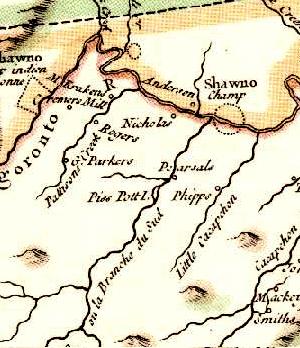
Piss Pot Island listed on the 1755 Jefferson and Fry Map in the South Branch Potomac River.
[edit] Licensing
| This file has been released into the public domain by the copyright holder, its copyright has expired, or it is ineligible for copyright. This applies worldwide. | ||||
|
||||
File history
Click on a date/time to view the file as it appeared at that time.
| Date/Time | Dimensions | User | Comment | |
|---|---|---|---|---|
| current | 03:12, 27 December 2005 | 300×348 (31 KB) | Caponer (Talk | contribs) | (Piss Pot Island listed on the 1755 Jefferson and Fry Map in the South Branch Potomac River.) |
- Search for duplicate files
- Edit this file using an external application
See the setup instructions for more information.
File links
The following pages on the English Wikipedia link to this file (pages on other projects are not listed):

