Image:Piedmontmap.png
From Wikipedia, the free encyclopedia
No higher resolution available.
Piedmontmap.png (250 × 250 pixels, file size: 35 KB, MIME type: image/png)
| | This is a file from the Wikimedia Commons. The description on its description page there is shown below.
|
[edit] Summary
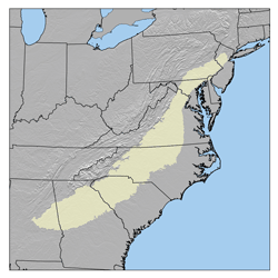
This is a map of the Piedment Region I made using USGS data and Major Land Resource Areas.
[edit] Licensing
|
File history
Click on a date/time to view the file as it appeared at that time.
| Date/Time | Dimensions | User | Comment | |
|---|---|---|---|---|
| current | 17:18, 25 May 2006 | 250×250 (35 KB) | Kmusser | (This is a map of the Piedment Region I made using USGS data and [http://soils.usda.gov/survey/geography/mlra/index.html Major Land Resource Areas].) |
File links
The following pages on the English Wikipedia link to this file (pages on other projects are not listed):

