Image:Pearl Harbor bombings map.jpg
From Wikipedia, the free encyclopedia
No higher resolution available.
Pearl_Harbor_bombings_map.jpg (769 × 512 pixels, file size: 115 KB, MIME type: image/jpeg)
| | This is a file from the Wikimedia Commons. The description on its description page there is shown below.
|
[edit] Summary
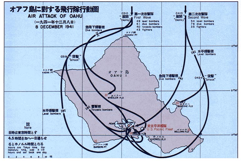
- Description
- Map showing the bombing of Pearl Harbor
Note that dates/times of the Japanese fleet location are given as Japan time, not local. (e.g., Dec 8 shown is Dec 7 local time in Hawaii, and 0310 hrs shown is 0740 local.)
日本語: 真珠湾攻撃(しんじゅわんこうげき)は、日本時間1941年12月8日(ハワイ現地時間12月7日)に大日本帝国海軍がアメリカ合衆国ハワイの真珠湾のアメリカ海軍のアメリカ太平洋艦隊と航空基地に対して行った奇襲攻撃のこと。
한국어: 진주만 공격 (일본어: 真珠湾攻撃, 영어: attack on Pearl Harbor)은 1941년 12월 7일 아침, 일본 해군 비행기들이 미국 하와이의 오아후 섬 진주만에 있는 미국 해군 육군 기지에 가한 기습 공격이다.
中文: 珍珠港事件是1941年12月7日清晨,日本联合舰队的飞机和微型潜艇突然袭击美国太平洋舰队基地珍珠港以及美国陆军和海军在夏威夷欧胡岛上的飞机场的事件。
- Source
- http://maps.library.umass.edu/raster/other_historical/genmac.html
- http://maps.library.umass.edu/raster/other_historical/images/genmac_gif/GenMac_13.gif
- License
- Originally from "Reports of General MacArthur"
-1966 Government printing office -- public domain
| This work is in the public domain in the United States because it is a work of the United States Federal Government under the terms of Title 17, Chapter 1, Section 105 of the US Code. See Copyright.
Note: This only applies to works of the Federal Government and not to the work of any individual U.S. state, territory, commonwealth, county, municipality, or any other subdivision. العربية | Български | Česky | Deutsch | English | Español | Français | Magyar | Italiano | 日本語 | 한국어 | Polski | Português | 中文(繁體) | 中文(简体) | +/- |
 |
[edit] Upload history at other projects
- WP:EN — Pearl Harbor bombings.jpg (source)
- 10:34, 19 July 2004 ¥ . . Raul654 (117755 bytes)
File history
Click on a date/time to view the file as it appeared at that time.
| Date/Time | Dimensions | User | Comment | |
|---|---|---|---|---|
| current | 18:22, 17 July 2005 | 769×512 (115 KB) | Get It | (;Description :Map showing the bombing of Pearl Harbor ;Source * http://maps.library.umass.edu/raster/other_historical/genmac.html * http://maps.library.umass.edu/raster/other_historical/images/genmac_gif/GenMac_13.gif ;License :Originally from "Report) |
File links
The following pages on the English Wikipedia link to this file (pages on other projects are not listed):

