Image:Partition of Hungary.png
From Wikipedia, the free encyclopedia
No higher resolution available.
Partition_of_Hungary.png (389 × 328 pixels, file size: 37 KB, MIME type: image/png)
| | This is a file from the Wikimedia Commons. The description on its description page there is shown below.
|
| Description |
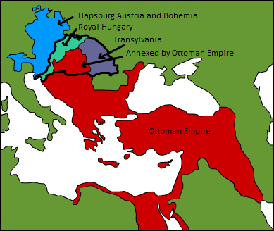
A map displaying position of the Kingdom of Hungary before 1526, and the 3 parts into which it was divided after the Battle of Mohács: Royal Hungary, Transylvania, and the part that was annexed by the Ottoman Empire. |
|---|---|
| Source |
Originally from en.wikipedia; description page is/was here. |
| Date |
2006-09-03 (first version); 2007-08-12 (last version) |
| Author |
Original uploader was Esoltas at en.wikipedia Later versions were uploaded by PANONIAN, DonatusHR at en.wikipedia. |
| Permission (Reusing this image) |
Released into the public domain (by the author). |
[edit] License information
| This image has been (or is hereby) released into the public domain by its author, Esoltas at the wikipedia project. This applies worldwide. In case this is not legally possible: |
[edit] Original upload log
(All user names refer to en.wikipedia)
- 2007-08-12 15:14 DonatusHR 389×328×8 (38357 bytes) Vraćeno na prijašnju inačicu
- 2007-08-12 15:13 DonatusHR 389×328×8 (35596 bytes) Vraćeno na prijašnju inačicu
- 2006-10-11 10:58 PANONIAN 389×328×8 (38357 bytes) corrected image
- 2006-09-03 15:00 Esoltas 389×328×8 (35596 bytes) A map displaying the original position of the Kingdom of Hungary, and the 3 lands that became of it after the Battle of Mohács: Royal Hungary, Transylvania, and the Ottoman-occupied section.
File history
Click on a date/time to view the file as it appeared at that time.
| Date/Time | Dimensions | User | Comment | |
|---|---|---|---|---|
| current | 17:58, 10 September 2007 | 389×328 (37 KB) | Sir Iain | ({{Information |Description=A map displaying position of the Kingdom of Hungary before 1526, and the 3 parts into which it was divided after the Battle of Mohács: Royal Hungary, Transylvania, and the part that was annexed by the Ottoman Empire. [[:en:Ca) |

