Image:Olomouc map 1757.jpg
From Wikipedia, the free encyclopedia
Size of this preview: 635 × 599 pixels
Full resolution (640 × 604 pixels, file size: 362 KB, MIME type: image/jpeg)
| | This is a file from the Wikimedia Commons. The description on its description page there is shown below.
|
| Description |
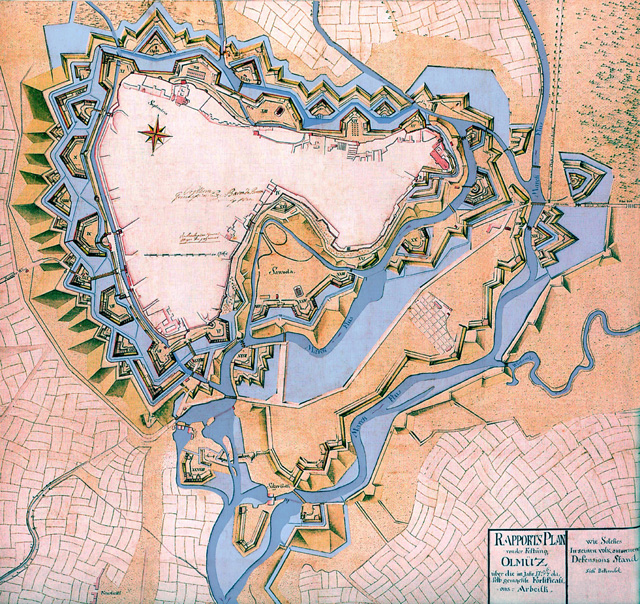
Česky: Plán dokončené bastionové pevnosti Olomouc z r. 1757 se zaplavením, ale hladina ještě nedosáhla maxima.
|
||
|---|---|---|---|
| Source | |||
| Date | |||
| Author | |||
| Permission (Reusing this image) |
|
||
| Other versions | no |
File history
Click on a date/time to view the file as it appeared at that time.
| Date/Time | Dimensions | User | Comment | |
|---|---|---|---|---|
| current | 10:55, 24 January 2007 | 640×604 (362 KB) | Snek01 | ({{Information |Description= *{{English}} Historcal map of Olomouc fortress (Czech Republic) in 1757. *{{Czech}} Plán dokončené bastionové pevnosti Olomouc z r. 1757 se zaplavením, ale hladina ještě nedos) |
File links
Metadata
This file contains additional information, probably added from the digital camera or scanner used to create or digitize it. If the file has been modified from its original state, some details may not fully reflect the modified file.
| Orientation | Normal |
|---|---|
| Horizontal resolution | 300 dpi |
| Vertical resolution | 300 dpi |
| Software used | Adobe Photoshop 7.0 CE |
| File change date and time | 21:50, 15 September 2003 |
| Color space | 65535 |

