Image:Okayama Castle map.jpg
From Wikipedia, the free encyclopedia
Size of this preview: 562 × 599 pixels
Full resolution (2,454 × 2,616 pixels, file size: 2.12 MB, MIME type: image/jpeg)
| | This is a file from the Wikimedia Commons. The description on its description page there is shown below.
|
[edit] en
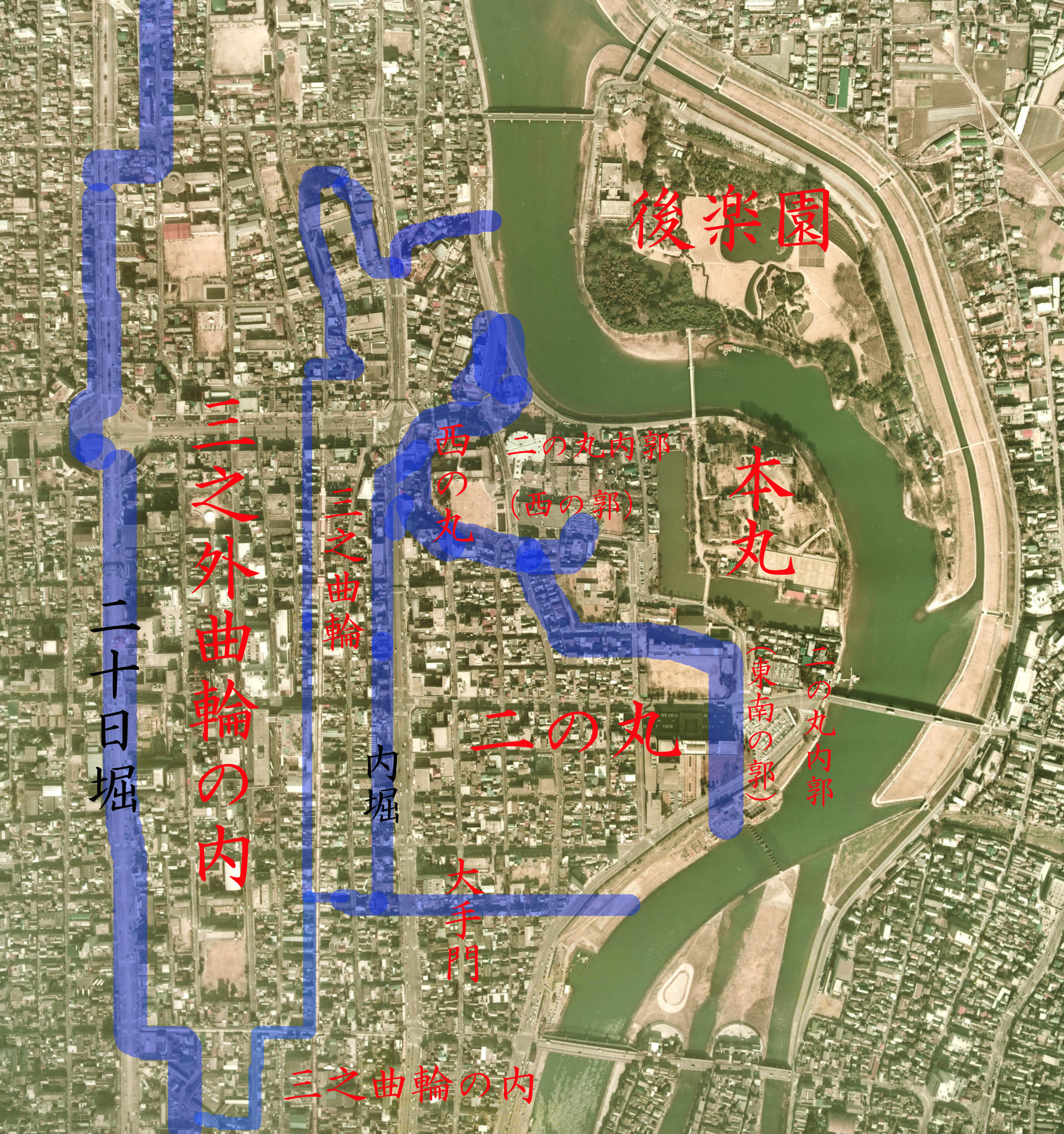
- Description: drew the territory on Aeral Photo of Okayama Castle and Korakuen garden, Okayama, Okayama, Japan
- Source: image from Country Picture Information (Color Aerial Photo) resized and drew by Reggaeman
- Date: 1974
[edit] ja
- 説明: 岡山県岡山市にある岡山城と後楽園の空中写真上に岡山城縄張りを描いた
- 空中写真の北方向:

- 整理番号: CKK-74-12
- 撮影年度: 昭和49年度 (1974年度)
- 地区名:岡山
- 撮影縮尺: 1/8000
- 地形図番号:NI-53-27-1
- 撮影コース: C16B
- 写真番号: 17
- 空中写真の北方向:
- 出典: 国土画像情報 (カラー空中写真)の写真を元にReggaemanにより編集・作成
[edit] Licensing
 |
The copyright holder of this file allows anyone to use it for any purpose, so long as it is marked as "National Land Image Information (Color Aerial Photograph), Ministry of Land, Infrastructure and Transport."
このファイルの著作権保有者は誰に対しても、以下の条件を守る限り自由に利用することを許可しています。条件:「国土画像情報(カラー空中写真)国土交通省」が出典であると明記する。 |
|
This image is copyrighted by the Ministry of Land, Infrastructure and Transport of Japan. For terms of use, see MLIT Web Mapping System (in Japanese) and Message from MLIT (in Japanese). この画像は国土交通省によって著作権が保持されたままになっています。利用条件については国土交通省ウェブマッピングシステムをご覧になるか、国土交通省からのメッセージをご覧ください。 Copyright © National Land Image Information (Color Aerial Photograph), Ministry of Land, Infrastructure and Transport |
File history
Click on a date/time to view the file as it appeared at that time.
| Date/Time | Dimensions | User | Comment | |
|---|---|---|---|---|
| current | 13:43, 11 June 2006 | 2,454×2,616 (2.12 MB) | Reggaeman | (== en == *'''Description:''' drew the territory on Aeral Photo of Okayama Castle and Korakuen garden, Okayama, Okayama, Japan *'''Source:''' image from [http://w3land.mlit.go.jp/WebGIS/ Country Picture Information (Color Aerial Photo)] resized and drew by) |
| 13:40, 11 June 2006 | 2,454×2,616 (2.12 MB) | Reggaeman | (== en == *'''Description:''' drew the territory on Aeral Photo of Okayama Castle and Korakuen garden, Okayama, Okayama, Japan *'''Source:''' image from [http://w3land.mlit.go.jp/WebGIS/ Country Picture Information (Color Aerial Photo)] resized and drew by) |
File links
Metadata
This file contains additional information, probably added from the digital camera or scanner used to create or digitize it. If the file has been modified from its original state, some details may not fully reflect the modified file.
| Orientation | Normal |
|---|---|
| Horizontal resolution | 400 dpi |
| Vertical resolution | 400 dpi |
| Software used | Adobe Photoshop Elements 2.0 |
| File change date and time | 22:30, 11 June 2006 |
| Color space | 65535 |

