Image:Ocmulgee watershed.png
From Wikipedia, the free encyclopedia
No higher resolution available.
Ocmulgee_watershed.png (300 × 334 pixels, file size: 108 KB, MIME type: image/png)
| | This is a file from the Wikimedia Commons. The description on its description page there is shown below.
|
[edit] Summary
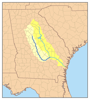
| Description |
This is a map of the Altamaha River system with the Ocmulgee River highlighted. I, Pfly, created it based on USGS data. |
|---|---|
| Source |
Own work. |
| Date |
January 5, 2007 |
| Author | |
| Permission (Reusing this image) |
see below |
[edit] Licensing
|
File history
Click on a date/time to view the file as it appeared at that time.
| Date/Time | Dimensions | User | Comment | |
|---|---|---|---|---|
| current | 04:27, 6 January 2007 | 300×334 (108 KB) | Pfly | ({{Information |Description=This is a map of the Altamaha River system with the Ocmulgee River highlighted. I, Pfly, created it based on USGS data. |Source=Own work. |Date=January) |
File links
The following pages on the English Wikipedia link to this file (pages on other projects are not listed):

