Image:Northwest territory.png
From Wikipedia, the free encyclopedia
No higher resolution available.
Northwest_territory.png (293 × 229 pixels, file size: 27 KB, MIME type: image/png)
| | This is a file from the Wikimedia Commons. The description on its description page there is shown below.
|
| Description |
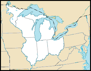
The en:Northwest Territory of the en:United States, circa 1787, time of the en:Northwest Ordinance. Created October 2004 by jengod, modified in July 2006 by Hotstreets. Based on a en:public domain U.S. government map: http://nationalatlas.gov/printable/images/preview/outline/rivers_lakes(u).gif |
|---|---|
| Source |
Originally from en.wikipedia; description page is/was here. |
| Date |
2006-06-24 (first version); 2006-07-30 (last version) |
| Author |
Original uploader was Hotstreets at en.wikipedia |
| Permission (Reusing this image) |
CC-BY-2.0-MAP; Released under the GNU Free Documentation License. |
[edit] License information
| This file is licensed under Creative Commons Attribution 2.0 License |

[edit] Original upload log
(All user names refer to en.wikipedia)
- 2006-07-30 01:35 Hotstreets 293×229×8 (27181 bytes) ==Northwest Territory map description== The [[Northwest Territory]] of the [[United States]], circa 1787, time of the [[Northwest Ordinance]]. Originally created October 2004 by jengod, modified in July 2006 by Hotstreets. Based on a [[public domain]] U.S
- 2006-06-24 03:25 Hotstreets 250×328×8 (106614 bytes) [[Northwest Territory]] map derived from http://www.nps.gov/libo/hrs/hrs5.htm. Colorized by myself.
File history
Click on a date/time to view the file as it appeared at that time.
| Date/Time | Dimensions | User | Comment | |
|---|---|---|---|---|
| current | 17:01, 11 April 2007 | 293×229 (27 KB) | Liftarn | ({{Information |Description=The en:Northwest Territory of the en:United States, circa 1787, time of the en:Northwest Ordinance. Created October 2004 by jengod, modified in July 2006 by Hotstreets. Based on a en:public domain U.S. govern) |
File links
The following pages on the English Wikipedia link to this file (pages on other projects are not listed):


.gif)