Image:Newfoundland and Labrador-map.png
From Wikipedia, the free encyclopedia
No higher resolution available.
Newfoundland_and_Labrador-map.png (280 × 230 pixels, file size: 14 KB, MIME type: image/png)
| | This is a file from the Wikimedia Commons. The description on its description page there is shown below.
|


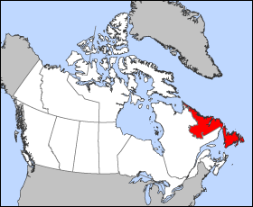
Map of Newfoundland and Labrador
Projection: Lambert azimuthal equal-area
Geospatial data from: The Atlas of Canada, The National Atlas of the United States and U.S. Geological Survey
Cartographer: John Fowler
| I, the copyright holder of this work, hereby release it into the public domain. This applies worldwide. In case this is not legally possible: Afrikaans | Alemannisch | Aragonés | العربية | Asturianu | Български | Català | Česky | Cymraeg | Dansk | Deutsch | Eʋegbe | Ελληνικά | English | Español | Esperanto | Euskara | Estremeñu | فارسی | Français | Galego | 한국어 | हिन्दी | Hrvatski | Ido | Bahasa Indonesia | Íslenska | Italiano | עברית | Kurdî / كوردی | Latina | Lietuvių | Latviešu | Magyar | Македонски | Bahasa Melayu | Nederlands | Norsk (bokmål) | Norsk (nynorsk) | 日本語 | Polski | Português | Ripoarisch | Română | Русский | Shqip | Slovenčina | Slovenščina | Српски / Srpski | Svenska | ไทย | Tagalog | Türkçe | Українська | Tiếng Việt | Walon | 中文(简体) | 中文(繁體) | zh-yue-hant | +/- |
File history
Click on a date/time to view the file as it appeared at that time.
| Date/Time | Dimensions | User | Comment | |
|---|---|---|---|---|
| current | 12:15, 24 March 2005 | 280×230 (14 KB) | Voyager | (Map of Newfoundland and Labrador Projection: Lambert azimuthal equal-area Geospatial data from: [http://atlas.gc.ca/ The Atlas of Canada], [http://www.nationalatlas.gov/ The National Atlas of the United States] and [http://www.usgs.gov U.S. Geological S) |
File links
- Newfoundland and Labrador
- User:Jnestorius/Regions with significant island landmass
- Canadian Senate divisions
- Image:Alberta-map.png
- Template:Canadian Provinces and Territories gallery
- Image:Ontario-map.png
- Image:Nunavut-map.png
- Image:Northwest Territories-map.png
- Image:Yukon Territory-map.png
- Image:Newfoundland and Labrador-map.png
- Image:Nova Scotia-map.png
- Image:Prince Edward Island-map.png
- Image:New Brunswick-map.png
- Image:Quebec-map.png
- Image:Manitoba-map.png
- Image:Saskatchewan-map.png
- History of Canada (1945-1960)
- User:DotDarkCloud
- Newfoundland referendums, 1948
- Higher education in Newfoundland and Labrador

