Image:New Brunswick map general.png
From Wikipedia, the free encyclopedia
Size of this preview: 649 × 600 pixels
Full resolution (1,659 × 1,533 pixels, file size: 1.4 MB, MIME type: image/png)
| | This is a file from the Wikimedia Commons. The description on its description page there is shown below.
|
[edit] Summary (Sommaire)
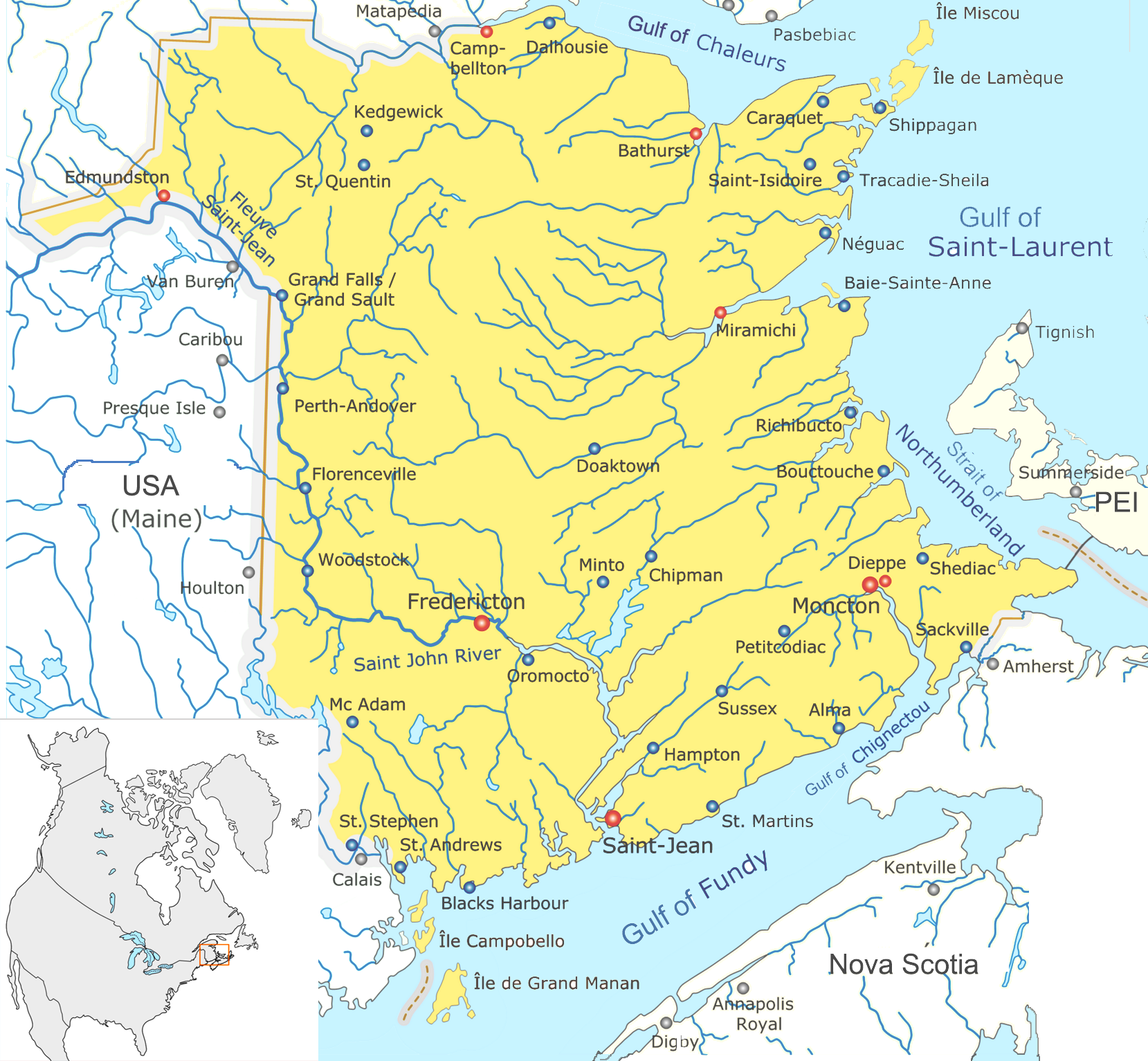
| Description |
Map of New Brunswick |
|||
|---|---|---|---|---|
| Source |
Translated and cropped from Image:Nouveau-Brunswick.png |
|||
| Date |
Jan 2008 |
|||
| Author | ||||
| Permission (Reusing this image) |
cc-by-3 |
|||
| Other versions |
|


[edit] Licensing
|
File history
Click on a date/time to view the file as it appeared at that time.
| Date/Time | Dimensions | User | Comment | |
|---|---|---|---|---|
| current | 16:37, 26 January 2008 | 1,659×1,533 (1.4 MB) | Qyd | (wash out color (better for superimpose)) |
| 00:37, 16 January 2008 | 1,659×1,533 (1.26 MB) | Qyd | ({{Information |Description=Map of New Brunswick |Source=Translated and cropped from Image:Nouveau-Brunswick.png |Date=Jan 2008 |Author= Qyd |Permission=cc-by-3 |other_versions=<gallery> Image:Nouveau-Brunswick.png|French version Image:Ne) |
File links
The following pages on the English Wikipedia link to this file (pages on other projects are not listed):
- Fredericton
- Saint John, New Brunswick
- List of cities in Canada
- Miramichi, New Brunswick
- Edmundston, New Brunswick
- Dieppe, New Brunswick
- Bathurst, New Brunswick
- Campbellton, New Brunswick
- Grand Manan Island (New Brunswick)
- Hartland, New Brunswick
- St. Stephen, New Brunswick
- Sackville, New Brunswick
- Quispamsis, New Brunswick
- Nackawic, New Brunswick
- Woodstock, New Brunswick
- Shediac, New Brunswick
- Perth-Andover, New Brunswick
- St. Andrews, New Brunswick
- Baker Brook, New Brunswick
- Memramcook, New Brunswick
- Grand Falls, New Brunswick
- Sussex, New Brunswick
- Tracadie-Sheila, New Brunswick
- Apohaqui, New Brunswick
- Oromocto, New Brunswick
- Salisbury, New Brunswick
- Riverview, New Brunswick
- Rothesay, New Brunswick
- Hampton, New Brunswick
- Beresford, New Brunswick
- Caraquet, New Brunswick
- New Maryland, New Brunswick
- Minto, New Brunswick
- Dalhousie, New Brunswick
- Bouctouche, New Brunswick
- Shippagan, New Brunswick
- Saint-Quentin, New Brunswick
- Cap-Pelé, New Brunswick
- Petit-Rocher, New Brunswick
- Richibucto, New Brunswick
- Petitcodiac, New Brunswick
- McAdam, New Brunswick
- Chipman, New Brunswick
- St. George, New Brunswick
- Hillsborough, New Brunswick
- Norton, New Brunswick
- Rogersville, New Brunswick
- Blacks Harbour, New Brunswick
- Saint-Antoine, New Brunswick
- Alma, New Brunswick
- Aroostook, New Brunswick
- Atholville, New Brunswick
- Bas-Caraquet, New Brunswick
- Belledune, New Brunswick
- Bertrand, New Brunswick
- Blackville, New Brunswick
- Balmoral, New Brunswick
- Charlo, New Brunswick
- Doaktown, New Brunswick
- Eel River Crossing, New Brunswick
- Grand Bay-Westfield, New Brunswick
- Kedgwick, New Brunswick
- Lamèque, New Brunswick
- Neguac, New Brunswick
- Plaster Rock, New Brunswick
- Pointe-Verte, New Brunswick
- Saint-Léonard, New Brunswick
- Sainte-Anne-de-Madawaska, New Brunswick
- Sussex Corner, New Brunswick
- Tide Head, New Brunswick
- Allardville, New Brunswick
- Douglas, New Brunswick
- Miscou Island
- Baie-Sainte-Anne, New Brunswick
- Lincoln, New Brunswick
- Aulac, New Brunswick
- Wikipedia talk:WikiProject New Brunswick
- Template:Location map Canada New Brunswick/doc
- Template:Location map Canada New Brunswick

