Image:Nautz1827.jpg
From Wikipedia, the free encyclopedia
Size of this preview: 800 × 581 pixels
Full resolution (2,312 × 1,680 pixels, file size: 2.74 MB, MIME type: image/jpeg)
| | This is a file from the Wikimedia Commons. The description on its description page there is shown below.
|
[edit] Summary
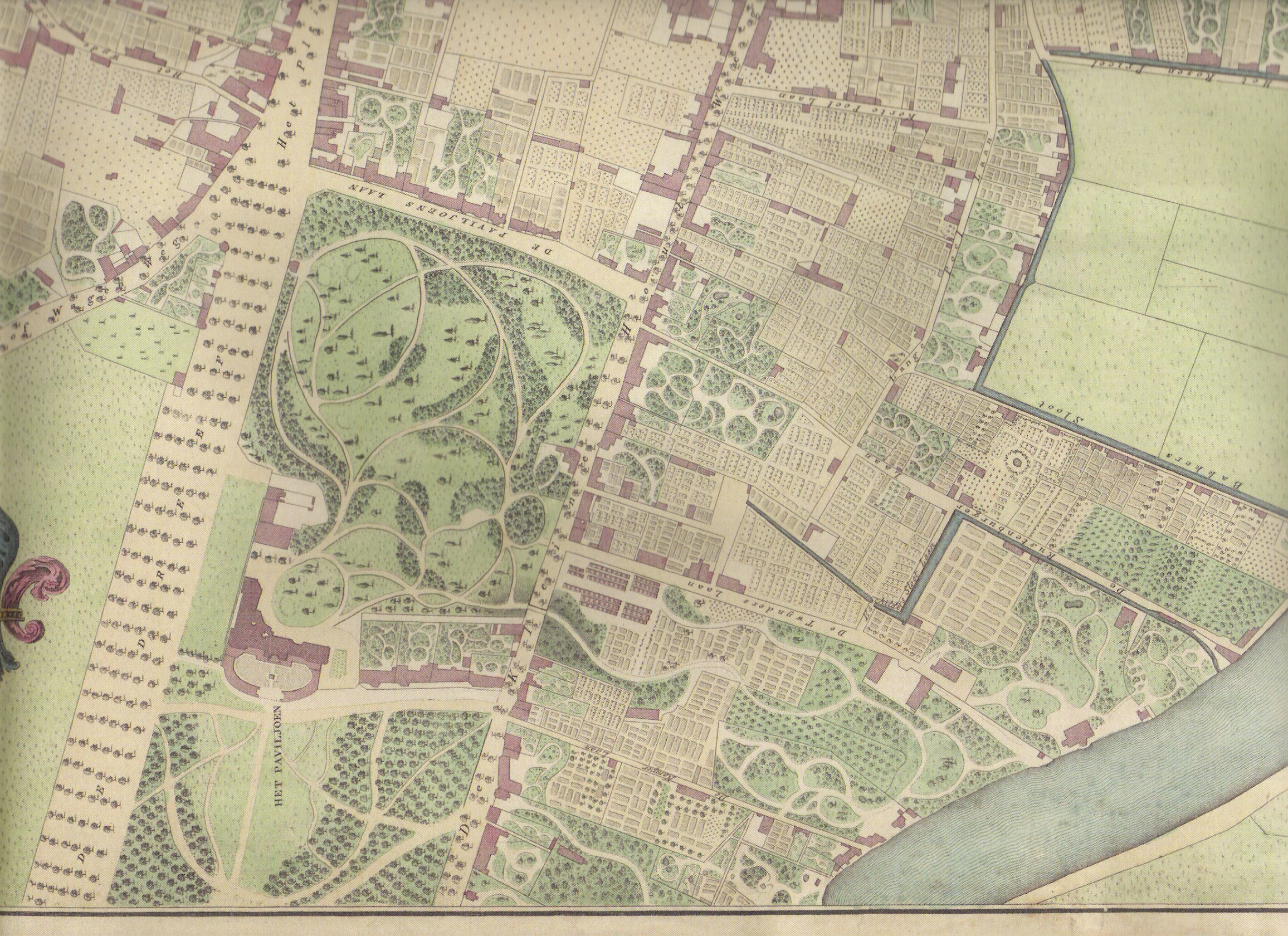
Southern portion of Nautz 1829 map of Haarlem showing Welgelegen as it was in 1827. Map date: 1829 Colored copper engraving by W.C. van Baarsel in Amsterdam. Source: Ferdinand Joseph Nautz(1785-1841) surveyor. Nautz was a member of a group of surveyors hired in 1817 to map the Dutch towns in order serve as a basis for taxes. The hand-colored and hand-drawn maps were created in 1822 by Nautz and his colleagues H.C. van Dooren and A. van Diggelen. They are in the possession of the National Archives. For the town of Haarlem, Nautz created a set of maps of Haarlem where not only ownership rights, but also houses were drawn. Quite popular, these maps were reproduced by book sellers and sold at the time for 3 guilders to travelers as the first city-maps. This set of maps belongs to the city of Haarlem, and has been used as the basis for city planning as late as 1900. In the archive museum of Haarlem, a model of the city is on show based on this map. Scanned from 2002 reproduction of one of many copies of the 'Nautz of Haarlem' in possession of North Holland Archives. Archiefdienst voor Kennemerland/Historische Museum Zuid-Kennemerland, Haarlem
[edit] Licensing
| This image (or other media file) is in the public domain because its copyright has expired. This applies to the United States, Canada, the European Union and those countries with a copyright term of life of the author plus 70 years.
العربية | Asturianu | Български | Català | Česky | Dansk | Deutsch | English | Ελληνικά | Esperanto | Español | Euskara | فارسی | Français | Gaeilge | Galego | עברית | हिन्दी | Bahasa Indonesia | Italiano | 日本語 | 한국어 | Kurdî / كوردی | Lietuvių | Magyar | Nederlands | Norsk (nynorsk) | Bahasa Melayu | Polski | Português | Română | Русский | Slovenčina | Slovenščina | Shqip | Suomi | Sámegiella | Türkçe | 中文(简体) | 中文(繁體) | 粵語 | +/- |
File history
Click on a date/time to view the file as it appeared at that time.
| Date/Time | Dimensions | User | Comment | |
|---|---|---|---|---|
| current | 15:22, 22 January 2007 | 2,312×1,680 (2.74 MB) | Jane023 | (== Summary == Southern portion of Nautz 1829 map showing Welgelegen as it was in 1827 1829 Colored copper engraving by W.C. van Baarsel in Amsterdam. Source: Ferdinand Joseph Nautz(1785-1841) surveyor Nautz was a member of a group of surveyors hired in 18) |

