Image:National-atlas-rhode-island.png
From Wikipedia, the free encyclopedia
No higher resolution available.
National-atlas-rhode-island.png (763 × 591 pixels, file size: 74 KB, MIME type: image/png)
| | This is a file from the Wikimedia Commons. The description on its description page there is shown below.
|
La bildo estas kopiita de wikipedia:en. La originala priskribo estas:
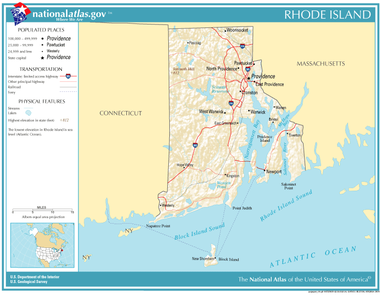
| This map was obtained from an edition of the National Atlas of the United States. Like almost all works of the U.S. federal government, works from the National Atlas are in the public domain. Online access: NationalAtlas.gov | 1970 print edition: Library of Congress, Perry-Castañeda Library |
|
| date/time | username | edit summary |
|---|---|---|
| 22:27, 30 November 2004 | en:User:Jengod | |
| 20:31, 4 November 2004 | en:User:Jengod | ({{PD-USGov}} <a href="/wiki/Category:Rhode_Island_maps" title="Category:Rhode Island maps">Category:Rhode Island maps</a>) |
[edit] Historio de la dosiero
Legend: (cur) = this is the current file, (del) = delete this old version, (rev) = revert to this old version.
Click on date to download the file or see the image uploaded on that date.
- (del) (cur) 11:32, 13 December 2004 . . en:User:Berkut Berkut ( en:User_talk:Berkut Talk) . . 763x591 (75354 bytes) (reduced file size)
- (del) (rev) 20:31, 4 November 2004 . . en:User:Jengod Jengod ( en:User_talk:Jengod Talk) . . 763x591 (189814 bytes) ({ { PD-USGov } } en:Category:Rhode_Island_maps Category:Rhode Island maps)
File history
Click on a date/time to view the file as it appeared at that time.
| Date/Time | Dimensions | User | Comment | |
|---|---|---|---|---|
| current | 11:31, 28 January 2006 | 763×591 (74 KB) | Maksim | (La bildo estas kopiita de wikipedia:en. La originala priskribo estas: {{PD-USGov-Atlas}} Category:Rhode Island maps {| border="1" ! date/time || username || edit summary |---- | 22:27, 30 November 2004 || en:User:Jengod || <nowiki></nowiki> |--) |
File links
The following pages on the English Wikipedia link to this file (pages on other projects are not listed):

