Image:NASA NYC VEGETATION.jpg
From Wikipedia, the free encyclopedia
Size of this preview: 505 × 599 pixels
Full resolution (1,187 × 1,409 pixels, file size: 940 KB, MIME type: image/jpeg)
| | This is a file from the Wikimedia Commons. The description on its description page there is shown below.
|
| Description |
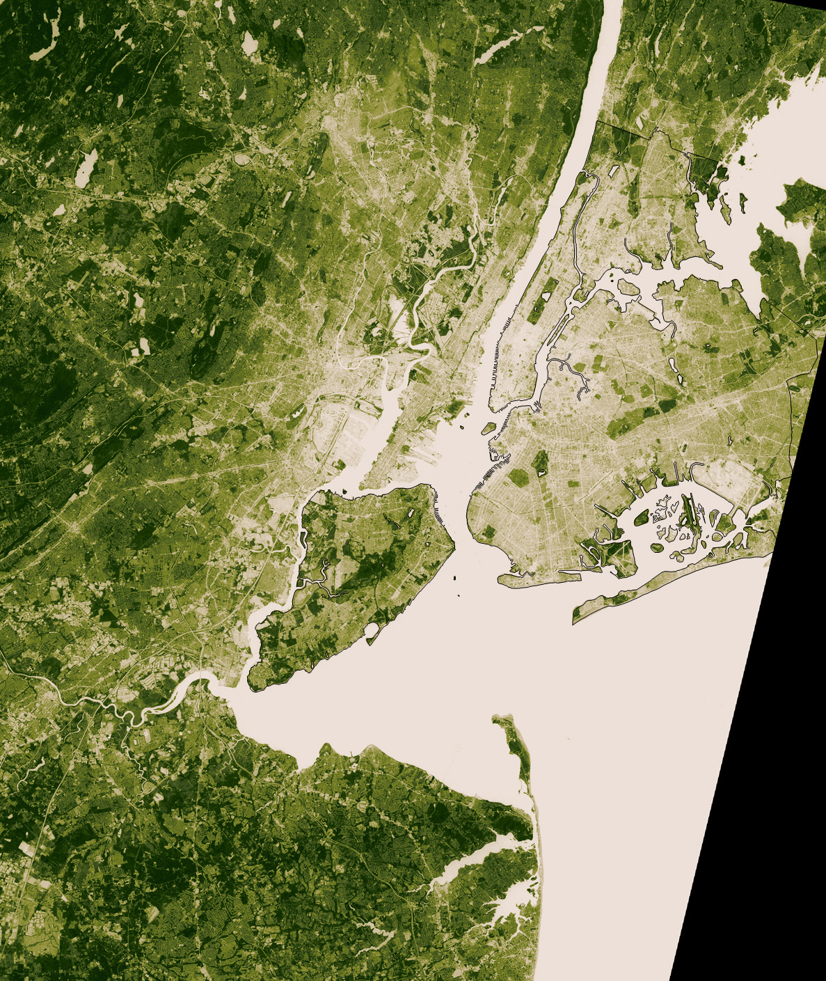
English: This image shows thermal infrared satellite data measured by NASA’s Landsat Enhanced Thematic Mapper Plus on August 14, one of the hottest days in New York?s 2002 summer. Landsat also collected vegetation data. The image shows vegetation from beige (sparse) to deep green (dense).
SOURCE: [1] |
|---|---|
| Source |
Transfered from en.wikipedia |
| Date |
2006-08-03 (first version); 2006-08-03 (last version) |
| Author |
Original uploader was Wv235 at en.wikipedia |
| Permission (Reusing this image) |
PD-USGOV-NASA. |
[edit] License information
|
|
This file is in the public domain because it was created by NASA. NASA copyright policy states that "NASA material is not protected by copyright unless noted". (NASA copyright policy page or JPL Image Use Policy).
Deutsch | English | Español | Français | Nederlands | Português | Русский | 中文(简体) | 中文(繁體) | +/- |
|
 |
Warnings:
|
[edit] Original upload log
The original description page is/was here. All following user names refer to en.wikipedia.
- 2006-08-03 23:52 Wv235 1187×1409×8 (962400 bytes) This image shows thermal infrared satellite data measured by NASA?s Landsat Enhanced Thematic Mapper Plus on August 14, one of the hottest days in New York?s 2002 summer. Landsat also collected vegetation data. The image shows vegetation from beige (s
- 2006-08-03 23:50 Wv235 1187×1409×8 (962400 bytes) This image shows thermal infrared satellite data measured by NASA?s Landsat Enhanced Thematic Mapper Plus on August 14, one of the hottest days in New York?s 2002 summer. Landsat also collected vegetation data. The image shows vegetation from beige (s
- 2006-08-03 23:49 Wv235 1187×1409×8 (962400 bytes) This image shows thermal infrared satellite data measured by NASA?s Landsat Enhanced Thematic Mapper Plus on August 14, one of the hottest days in New York?s 2002 summer. Landsat also collected vegetation data. The image shows vegetation from beige (s
File history
Click on a date/time to view the file as it appeared at that time.
| Date/Time | Dimensions | User | Comment | |
|---|---|---|---|---|
| current | 02:25, 6 December 2007 | 1,187×1,409 (940 KB) | File Upload Bot (Magnus Manske) | ( {{BotMoveToCommons|en.wikipedia}} {{Information |Description={{en|This image shows thermal infrared satellite data measured by NASA?s Landsat Enhanced Thematic Mapper Plus on August 14, one of the hottest days in New York?s 2002 summer. Landsat also coll) |
File links
The following pages on the English Wikipedia link to this file (pages on other projects are not listed):
Metadata
This file contains additional information, probably added from the digital camera or scanner used to create or digitize it. If the file has been modified from its original state, some details may not fully reflect the modified file.
| Width | 3912 |
|---|---|
| Height | 3267 |
| Bits per component | 8 |
| Compression scheme | 5 |
| Pixel composition | 3 |
| Image title | IDL TIFF file |
| Orientation | Normal |
| Number of components | 1 |
| Horizontal resolution | 100 dpi |
| Vertical resolution | 100 dpi |
| Software used | Adobe Photoshop CS2 Macintosh |
| File change date and time | 17:17, 2 August 2006 |
| Color space | 65535 |

