Image:Mweru Wantipa from space.jpg
From Wikipedia, the free encyclopedia
No higher resolution available.
Mweru_Wantipa_from_space.jpg (325 × 198 pixels, file size: 15 KB, MIME type: image/jpeg)
| | This is a file from the Wikimedia Commons. The description on its description page there is shown below.
|
[edit] Summary
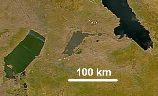
| Description |
Lake Mweru Wantipa (Mweru Marshes) in northern Zambia photographed from space. Mweru Wantipa is a shallow muddy lake shown in the centre between the greenish Lake Mweru and the dark blue Lake Tanganyika. |
|---|---|
| Source |
cropped from: NASA Visible Earth website |
| Date |
26 March 2007 (Original 2000-07-23) |
| Author |
NASA, Credit SeaWiFS Project, NASA/Goddard Space Flight Center, and ORBIMAGE |
| Permission (Reusing this image) |
Public domain |
[edit] Licensing
| This image is from the Sea-viewing Wide Field-of-view Sensor (SeaWiFS) Project. Satellite data captured by the SeaWIFS sensor are released into the public domain 5 years after capture.[1] Data less than five years old can be re-used only for educational or scientific purposes; any commercial use of such images must be coordinated with ORBIMAGE/GeoEye. |
File history
Click on a date/time to view the file as it appeared at that time.
| Date/Time | Dimensions | User | Comment | |
|---|---|---|---|---|
| current | 05:56, 27 March 2007 | 325×198 (15 KB) | Rexparry sydney | ({{Information |Description=Lake Mweru Wantipa (Mweru Marshes) in northern Zambia photographed from space. Mweru Wantipa is a shallow muddy lake shown in the centre between the greenish Lake Mweru and the dark blue Lake Tanganyika. |Source=[htt) |
File links
The following pages on the English Wikipedia link to this file (pages on other projects are not listed):

