Image:Milpitas layout.gif
From Wikipedia, the free encyclopedia
No higher resolution available.
Milpitas_layout.gif (500 × 375 pixels, file size: 28 KB, MIME type: image/gif)
| | This is a file from the Wikimedia Commons. The description on its description page there is shown below.
|
[edit] Summary
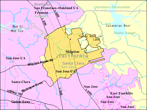
| Description |
U.S. Census map of Milpitas. The two isolated pockets of unincorporated land in the midst of city land is private ranch land that has been owned by local families since the 1800s. |
|---|---|
| Source | |
| Date |
May 2005 |
| Author | |
| Permission (Reusing this image) |
Public domain |
[edit] Licensing
| This image or other media is a work of a United States Census Bureau employee, taken or made during the course of an employee's official duties. As a work of the U.S. federal government, the image is in the public domain |  |
[edit] Original upload log
This image was copied from wikipedia:en. Transwiki approved by: w:en:User:Dmcdevit
[edit] File history
| date/time | username | resolution | size | edit summary |
|---|---|---|---|---|
| 03:38, 16 May 2005 | w:en:User:Milpitas guy | 500×375 | 28 KB | {{PD-USGov-DOC-Census}} |
[edit] Image description page history
| link | date/time | username | edit summary |
|---|---|---|---|
| [1] | 07:41, 16 September 2007 | w:en:User:Dmcdevit | |
| [2] | 01:19, 28 October 2005 | w:en:User:Milpitas guy | |
| [3] | 21:48, 19 May 2005 | w:en:User:Milpitas guy | |
| [4] | 03:38, 16 May 2005 | w:en:User:Milpitas guy | ({{PD-USGov-DOC-Census}}) |
File history
Click on a date/time to view the file as it appeared at that time.
| Date/Time | Dimensions | User | Comment | |
|---|---|---|---|---|
| current | 13:24, 16 September 2007 | 500×375 (28 KB) | BetacommandBot | (Transwiki approved by: w:en:User:Dmcdevit This image was copied from wikipedia:en. The original description was: w:en:Milpitas. Image at http://factfinder.census.gov/leg1/51/38945051.gif The two isolated pockets of unincorporated land in the mi) |
File links
The following pages on the English Wikipedia link to this file (pages on other projects are not listed):


![[1]](http://en.wikipedia.org/w/index.php?title=Image:Milpitas_layout.gif&redirect=no&oldid=26667647)
![[3]](http://en.wikipedia.org/w/index.php?title=Image:Milpitas_layout.gif&redirect=no&oldid=17527346)
![[4]](http://en.wikipedia.org/w/index.php?title=Image:Milpitas_layout.gif&redirect=no&oldid=13947279)