Image:Mid-atlantic ridge map.png
From Wikipedia, the free encyclopedia
No higher resolution available.
Mid-atlantic_ridge_map.png (200 × 415 pixels, file size: 21 KB, MIME type: image/png)
| | This is a file from the Wikimedia Commons. The description on its description page there is shown below.
|
| Description |
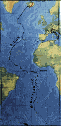
small image showing the location of the Mid-Atlantic ridge |
|---|---|
| Source | |
| Date | |
| Author |
originally uploaded on the English wikipedia: 14:51, 21 October 2003 . . JamesDay (Talk |
| Permission (Reusing this image) |
Copyright: public domain. US Geological Survey image. Copyright statement: [2] "Information presented on this website is considered public information and may be distributed or copied. Use of appropriate byline/photo/image credit is requested." |
| This image is in the public domain because it contains materials that originally came from the United States Geological Survey, an agency of the United States Department of Interior. For more information, see the official USGS copyright policy |
|
File history
Click on a date/time to view the file as it appeared at that time.
| Date/Time | Dimensions | User | Comment | |
|---|---|---|---|---|
| current | 11:02, 1 February 2007 | 200×415 (21 KB) | Woudloper | ({{Information |Description=small image showing the location of the Mid-Atlantic ridge |Source=[http://pubs.usgs.gov/publications/text/ridge.html] |Date= |Author=originally uploaded on the English wikipedia: 14:51, 21 October 2003 . . JamesDay (Talk | cont) |
File links
The following pages on the English Wikipedia link to this file (pages on other projects are not listed):

