Image:Mappa mundi Hereford 1300 explained.png
From Wikipedia, the free encyclopedia
No higher resolution available.
Mappa_mundi_Hereford_1300_explained.png (612 × 369 pixels, file size: 50 KB, MIME type: image/png)
| | This is a file from the Wikimedia Commons. The description on its description page there is shown below.
|
[edit] Beschreibung
| Description |
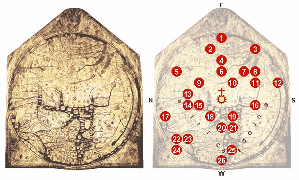
Image:Hereford Mappa Mundi 1300.jpg, edited, some details explained. |
|---|---|
| Source |
Image:Hereford Mappa Mundi 1300.jpg, notes in: 1.; 2.; 3.; [1]. |
| Date |
20070226-28 |
| Author |
WolfgangW. |
| Permission (Reusing this image) |
- |
| Other versions |


|
[edit] Licensing

File history
Click on a date/time to view the file as it appeared at that time.
| Date/Time | Dimensions | User | Comment | |
|---|---|---|---|---|
| current | 20:25, 28 February 2007 | 612×369 (50 KB) | I.R. Annie IP. | |
| 14:29, 26 February 2007 | 607×697 (131 KB) | I.R. Annie IP. | ({{Information |Description=Image:Hereford Mappa Mundi 1300.jpg, edited, some details explained. At the center of the map: Jerusalem, crowned by the Crucifix. 1 - Paradise 2 - The fabulous Island of Taphana, sometimes (possibly mis-)interpreted as Sri La) |

